1970s Maps of Ventura, Iowa
Explore 2 historic maps of Ventura from the 1970s. These maps offer a rare glimpse into what life looked like during the 1970s — showing old roads, neighborhoods, homes, and landmarks that have changed or disappeared over time.
Whether you're researching your family's past, planning a metal detecting trip, or studying how Ventura's landscape evolved across the 1970s, these high-resolution maps are a powerful tool for exploring the history of this region.
- Focus on a specific era: All maps on this page are from the 1970s, giving you a focused view of this time period.
- See what’s changed: Compare century-old streets, trails, and buildings to today's modern landscape using overlays and satellite layers.
- Research with precision: Use these maps for genealogy, historical research, land use analysis, or educational projects.
- View, download, or print: Maps are fully viewable online in high resolution, and can be downloaded or printed for your own records.
Start exploring Ventura's history through authentic maps from the 1970s. This is your window into the past.
Ventura, IA maps
(2)- 1972 Map of Clear Lake West
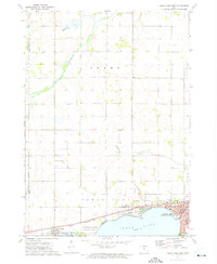 1972 Clear Lake West1972 Print · USGSThe western shores of Clear Lake were well-established by the early seventies, balancing lakeside recreation with a busy rail corridor. Researchers can trace local genealogy at Grant Cem or locate former campus sites like Central Sch and Jr High Sch.
 - 1972 Map of Ventura Heights, 1975 Print
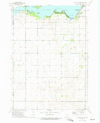 1972 Ventura Heights1975 Print · USGSClear Lake's northern and western reaches were well-established for leisure and rural living by the early seventies. Genealogists and local historians can trace the development of Ventura, locate family sites near the Lake Side Ch, or map early property lines in Union township.
End of results
Showing maps 1-2 of 2
Top cities near Ventura
- Mason City historical maps
- Clear Lake historical maps
- Forest City historical maps
- Garner historical maps
- Sheffield historical maps
- Klemme historical maps
See more
Frequently asked questions
- What are the different types of historical maps available for Ventura?
- What is the oldest map of Ventura?
- Where can I purchase historical maps of Ventura for my home or office?
- Where can I download high-res historical maps of Ventura?
- Are there historical topographic maps available for Ventura?
- Is there historical aerial imagery available for Ventura?
- Where are historical maps of Ventura sourced from?