1970s Maps of Chickasaw County, Iowa
Explore 11 historic maps of Chickasaw County from the 1970s. These maps offer a rare glimpse into what life looked like during the 1970s — showing old roads, neighborhoods, homes, and landmarks that have changed or disappeared over time.
Whether you're researching your family's past, planning a metal detecting trip, or studying how Chickasaw County's landscape evolved across the 1970s, these high-resolution maps are a powerful tool for exploring the history of this region.
- Focus on a specific era: All maps on this page are from the 1970s, giving you a focused view of this time period.
- See what’s changed: Compare century-old streets, trails, and buildings to today's modern landscape using overlays and satellite layers.
- Research with precision: Use these maps for genealogy, historical research, land use analysis, or educational projects.
- View, download, or print: Maps are fully viewable online in high resolution, and can be downloaded or printed for your own records.
Start exploring Chickasaw County's history through authentic maps from the 1970s. This is your window into the past.
Chickasaw County, IA maps
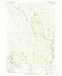
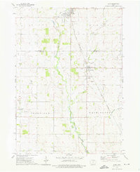
(11)- 1971 Map of Alpha, 1973 Print
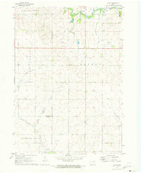 1971 Alpha1973 Print · USGSNortheast Iowa farmland is captured here in the early seventies, showcasing a landscape of section-line roads and creek-side settlements. Genealogists and historians can trace local family roots through Bethel Cem and Wilson Grove Cem or locate old industrial sites like the Quarry and Gravel Pits.
 - 1971 Map of Tripoli NW, 1973 Print
 1971 Tripoli NW1973 Print · USGSChickasaw and Bremer Counties are mapped here in the early seventies, showing a rural landscape defined by the Wapsipinicon River. Researchers can locate family landmarks like Cagley Cem, Township Cem, and the small community of Republic.
 - 1971 Map of Fredericksburg, 1973 Print
 1971 Fredericksburg1973 Print · USGSThe Fredericksburg area in the early seventies shows a landscape defined by the Chicago and North Western rail line and the winding East Fork Wapsipinicon River. Genealogists and local historians can locate family burial plots at Mentor Cem and Zion Cem, or trace the rural airstrips and small-town streets of the day.
 - 1971 Map of Frederika, 1973 Print
 1971 Frederika1973 Print · USGSBremer and Chickasaw counties come to life in this early 1970s survey of the river valleys in northeast Iowa. Researchers can trace rural life through landmarks like Williamstown, the small St Johns Cem, and the unique Leo Aero Ranch Landing Strip near the river.
 - 1971 Map of Bassett, 1973 Print
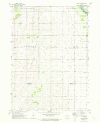
 1971 Bassett1973 Print · USGSChickasaw and Floyd Counties are documented here in the early 1970s, showing the rural landscape as the river and rail lines shaped local industry. Genealogists and historians can locate the Cedar View Cem, the village of Bassett, and the grounds of Bunns Woods County Park.
 - 1971 Map of Colwell, 1973 Print
 1971 Colwell1973 Print · USGSUpper Iowa farm country and the meeting of four counties are captured here in the early seventies as the rail era left its mark on the land. Genealogists and historians can trace the Old Grade Railroad, find St Cecilia Ch, and locate Beckwith Cem.
 - 1971 Map of Nashua, 1973 Print
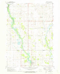
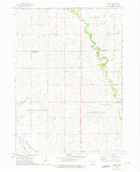
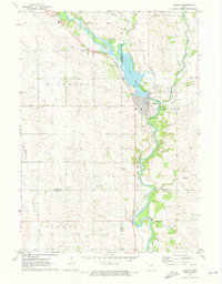 1971 Nashua1973 Print · USGSNashua and the Cedar River valleys are captured here in the early seventies, showing a landscape of small-town industry and riverfront recreation. Genealogists can locate Saint Michaels Cem and the famous Little Brown Church in the Vale, while researchers can trace the Illinois Central rail line.
 - 1972 Map of Ionia, 1976 Print
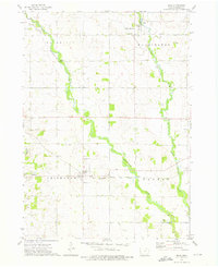 1972 Ionia1976 Print · USGSChickasaw County in the early seventies is defined by the winding Wapsipinicon River and the small-town hubs that grew along the rail lines. Local historians can trace the paths of the Chicago Milwaukee St Paul and Pacific through Ionia or locate family sites at St Boniface Cem and Rowley Hill Cem.
 - 1972 Map of Elma, 1976 Print
 1972 Elma1976 Print · USGSThe rural border of Howard and Chickasaw counties comes into focus in the early 1970s as the rail and river networks shaped local life. Genealogists and historians can trace the Chicago and North Western line through Elma and Alta Vista, or locate Deerfield Cem near the river.
 - 1972 Map of Jerico, 1976 Print
 1972 Jerico1976 Print · USGSChickasaw and Howard counties appear in the early seventies as a patchwork of established family farms and creek valleys. Genealogists can trace rural homesteads near Jerico, the Chicago and North Western rail line, and the banks of Crane Creek.
 - 1972 Map of New Hampton, 1976 Print
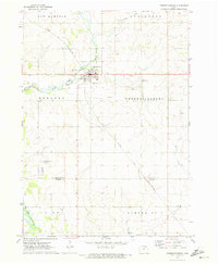
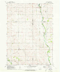
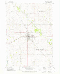 1972 New Hampton1976 Print · USGSNew Hampton and its surrounding Chickasaw County townships are captured here in the early 1970s at the height of its rail-era importance. Genealogists and local historians can trace the paths of the Chicago and North Western railroad or locate family plots at St Marys Cem and Devon.
End of results
Showing maps 1-11 of 11
Top cities of Chickasaw County
- New Hampton historical maps
- Nashua historical maps
- Fredericksburg historical maps
- Lawler historical maps
- Alta Vista historical maps
- Ionia historical maps
See more
Frequently asked questions
- What are the different types of historical maps available for Chickasaw County?
- What is the oldest map of Chickasaw County?
- Where can I purchase historical maps of Chickasaw County for my home or office?
- Where can I download high-res historical maps of Chickasaw County?
- Are there historical topographic maps available for Chickasaw County?
- Is there historical aerial imagery available for Chickasaw County?
- Where are historical maps of Chickasaw County sourced from?