1950s Maps of Clayton County, Iowa
Explore 5 historic maps of Clayton County from the 1950s. These maps offer a rare glimpse into what life looked like during the 1950s — showing old roads, neighborhoods, homes, and landmarks that have changed or disappeared over time.
Whether you're researching your family's past, planning a metal detecting trip, or studying how Clayton County's landscape evolved across the 1950s, these high-resolution maps are a powerful tool for exploring the history of this region.
- Focus on a specific era: All maps on this page are from the 1950s, giving you a focused view of this time period.
- See what’s changed: Compare century-old streets, trails, and buildings to today's modern landscape using overlays and satellite layers.
- Research with precision: Use these maps for genealogy, historical research, land use analysis, or educational projects.
- View, download, or print: Maps are fully viewable online in high resolution, and can be downloaded or printed for your own records.
Start exploring Clayton County's history through authentic maps from the 1950s. This is your window into the past.
Clayton County, IA maps
(5)- 1955 Map of Cassville, 1957 Print
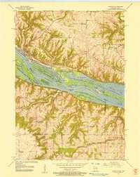 1955 Cassville1957 Print · USGSMid-century life along the Mississippi River bluffs is captured here as the transition from one-room schools to larger districts begins. Genealogists can trace family roots at St Charles Cem and Advent Ch or locate discontinued sites like Hefel Sch.2 unique versions available
 - 1957 Map of Turkey River, 1959 Print
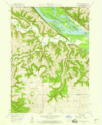 1957 Turkey River1959 Print · USGSNortheast Iowa at the confluence of the Turkey and Mississippi Rivers shows a landscape of deep hollows and river-bottom railroads in the late fifties. Genealogists can locate family landmarks like St Johns Cem, the settlement of Millville, and the Goshen Ch.3 unique versions available
 - 1957 Map of Colesburg, 1959 Print
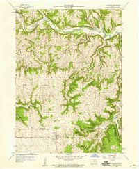 1957 Colesburg1959 Print · USGSThe tri-county border area of Northeast Iowa is captured here during the late 1950s, showing the rural landscape around Colesburg. Family historians can locate several burial sites and country churches, including Oak Hill Cem, Zion Ch, and the remote Hanna Cem.2 unique versions available
 - 1958 Map of La Crosse, 1979 Print
 1958 La Crosse1979 Print · USGSThe Driftless Area of Wisconsin and Iowa is captured here during the late seventies, showing the intricate river valleys and ridge-top settlements. Genealogists and historians can trace the rail corridors of the Soo Line or locate landmarks like Grandad Bluff and Effigy Mounds National Monument.2 unique versions available
 - 1959 Map of Dubuque, 1982 Print
 1959 Dubuque1982 Print · USGSThe Tri-State region comes alive in the mid-twentieth century as a hub of river commerce and rail transit. Genealogists and historians can trace the paths of the Illinois Central Gulf through Dubuque or locate the Savanna Ordnance Depot and Lock and Dam No 11.
End of results
Showing maps 1-5 of 5
Top cities of Clayton County
- Guttenberg historical maps
- Monona historical maps
- Elkader historical maps
- Strawberry Point historical maps
- Garnavillo historical maps
- McGregor historical maps
See more
Frequently asked questions
- What are the different types of historical maps available for Clayton County?
- What is the oldest map of Clayton County?
- Where can I purchase historical maps of Clayton County for my home or office?
- Where can I download high-res historical maps of Clayton County?
- Are there historical topographic maps available for Clayton County?
- Is there historical aerial imagery available for Clayton County?
- Where are historical maps of Clayton County sourced from?