1980s Maps of Toronto, Iowa
Explore 2 historic maps of Toronto from the 1980s. These maps offer a rare glimpse into what life looked like during the 1980s — showing old roads, neighborhoods, homes, and landmarks that have changed or disappeared over time.
Whether you're researching your family's past, planning a metal detecting trip, or studying how Toronto's landscape evolved across the 1980s, these high-resolution maps are a powerful tool for exploring the history of this region.
- Focus on a specific era: All maps on this page are from the 1980s, giving you a focused view of this time period.
- See what’s changed: Compare century-old streets, trails, and buildings to today's modern landscape using overlays and satellite layers.
- Research with precision: Use these maps for genealogy, historical research, land use analysis, or educational projects.
- View, download, or print: Maps are fully viewable online in high resolution, and can be downloaded or printed for your own records.
Start exploring Toronto's history through authentic maps from the 1980s. This is your window into the past.
Toronto, IA maps
(2)- 1980 Map of Lost Nation, 1981 Print
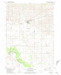 1980 Lost Nation1981 Print · USGSClinton County’s agricultural heartland is captured here in the late 1970s as the rail era transitioned into a landscape of quiet rural townships. Genealogists and local historians can locate many small burial sites including Sacred Heart Cem, Rose Hill Cem, and the church at Smithtown Ch.
 - 1984 Map of Davenport, 1985 Print
 1984 Davenport1985 Print · USGSThe Quad Cities and the eastern Iowa riverlands are captured in the mid-eighties as industry and conservation converged along the Mississippi. Genealogists and local historians can trace rural roots through Stender Church, Oxford Mills, and the Elmwood Cem burial grounds.2 unique versions available
End of results
Showing maps 1-2 of 2
Top cities near Toronto
- Maquoketa historical maps
- Clarence historical maps
- Lowden historical maps
- Wheatland historical maps
- Grand Mound historical maps
- Wyoming historical maps
See more
Frequently asked questions
- What are the different types of historical maps available for Toronto?
- What is the oldest map of Toronto?
- Where can I purchase historical maps of Toronto for my home or office?
- Where can I download high-res historical maps of Toronto?
- Are there historical topographic maps available for Toronto?
- Is there historical aerial imagery available for Toronto?
- Where are historical maps of Toronto sourced from?