1900-1909 Maps of Clive, Iowa
Explore 3 historic maps of Clive from 1900-1909. These maps offer a rare glimpse into what life looked like during the 1900s — showing old roads, neighborhoods, homes, and landmarks that have changed or disappeared over time.
Whether you're researching your family's past, planning a metal detecting trip, or studying how Clive's landscape evolved across the 1900s, these high-resolution maps are a powerful tool for exploring the history of this region.
- Focus on a specific era: All maps on this page are from the 1900s, giving you a focused view of this time period.
- See what’s changed: Compare century-old streets, trails, and buildings to today's modern landscape using overlays and satellite layers.
- Research with precision: Use these maps for genealogy, historical research, land use analysis, or educational projects.
- View, download, or print: Maps are fully viewable online in high resolution, and can be downloaded or printed for your own records.
Start exploring Clive's history through authentic maps from the 1900s. This is your window into the past.
Clive, IA maps
(3)- 1905 Map of Des Moines, 1954 Print
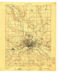
 1905 Des Moines1954 Print · USGSAt the dawn of the twentieth century, the state capital was a thriving rail hub where the Des Moines River met a complex network of iron rails. Genealogists and historians can trace early neighborhood development near the State Fairgrounds or locate family roots near rural landmarks like Red Brick School and Valley Junction.
 - 1907 Map of Des Moines
 1907 Des Moines1907 Print · USGSThe capital city and its surrounding coal-and-rail towns are shown in detail at the start of the twentieth century. Genealogists can locate family homesteads near Fort Des Moines or trace ancestors in vanished settlements like Oralabor, Saylorville, and Valley Junction.3 unique versions available
 - 1908 Map of Waukee
 1908 Waukee1908 Print · USGSDallas County at the turn of the century shows a landscape shaped by competing railroads and the winding Raccoon River. Genealogists and local historians can trace early schoolhouse locations like Valley Grove School and the original rail footprints of Waukee and Van Meter.2 unique versions available
End of results
Showing maps 1-3 of 3
Top cities near Clive
- Des Moines historical maps
- West Des Moines historical maps
- Ankeny historical maps
- Urbandale historical maps
- Johnston historical maps
- Waukee historical maps
See more
Frequently asked questions
- What are the different types of historical maps available for Clive?
- What is the oldest map of Clive?
- Where can I purchase historical maps of Clive for my home or office?
- Where can I download high-res historical maps of Clive?
- Are there historical topographic maps available for Clive?
- Is there historical aerial imagery available for Clive?
- Where are historical maps of Clive sourced from?