1980s Maps of Crawford County, Iowa
Explore 6 historic maps of Crawford County from the 1980s. These maps offer a rare glimpse into what life looked like during the 1980s — showing old roads, neighborhoods, homes, and landmarks that have changed or disappeared over time.
Whether you're researching your family's past, planning a metal detecting trip, or studying how Crawford County's landscape evolved across the 1980s, these high-resolution maps are a powerful tool for exploring the history of this region.
- Focus on a specific era: All maps on this page are from the 1980s, giving you a focused view of this time period.
- See what’s changed: Compare century-old streets, trails, and buildings to today's modern landscape using overlays and satellite layers.
- Research with precision: Use these maps for genealogy, historical research, land use analysis, or educational projects.
- View, download, or print: Maps are fully viewable online in high resolution, and can be downloaded or printed for your own records.
Start exploring Crawford County's history through authentic maps from the 1980s. This is your window into the past.
Crawford County, IA maps
(6)- 1980 Map of Boyer
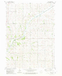 1980 Boyer1980 Print · USGSCrawford County's river-and-rail corridor is captured here in the late seventies. Genealogists and local historians can trace the paths of the Illinois Central Gulf railroad and locate rural landmarks like Ells Station and Boyer.
 - 1980 Map of Harlan
 1980 Harlan1980 Print · USGSWestern Iowa and the Nebraska borderlands are shown in the early eighties as a vital corridor of rail and river commerce. Genealogists and local historians can trace family roots through old rural crossroads like Beebeetown and Westphalia, or locate landmarks like Rose Hill Cem.
 - 1980 Map of Vail NE
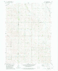 1980 Vail NE1980 Print · USGSThe rolling farmland along the Carroll, Sac, and Crawford county lines is captured here in the mid-1970s. Researchers can locate family burial plots and rural landmarks like Wheatland Ch Cem and the Chicago and North Western tracks.
 - 1980 Map of Arcadia
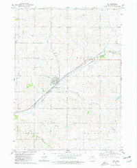
 1980 Arcadia1980 Print · USGSThe rail-driven communities of Arcadia and Westside are captured in the late 1970s as agricultural hubs along the Chicago and North Western. Researchers can trace old family burial sites at Arcadia Cem and St Johns Cem or follow the path of the Boyer River.
 - 1980 Map of Vail, 1981 Print
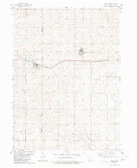
 1980 Vail1981 Print · USGSThe Boyer River valley in Crawford County comes into focus during the late 1970s. Trace the rail lines of the Chicago and North Western or find family landmarks like King Cem and St Anns Cem.
 - 1985 Map of Ida Grove
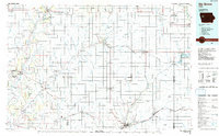 1985 Ida Grove1985 Print · USGSWestern Iowa's agricultural heartland is documented in the mid-1980s, showcasing a network of grain-hauling rail lines and river valley settlements. Genealogists and historians can trace family locations across Ida Grove and Denison or locate landmarks like Black Hawk Lake.2 unique versions available
End of results
Showing maps 1-6 of 6
Top cities of Crawford County
- Denison historical maps
- Schleswig historical maps
- Manilla historical maps
- Charter Oak historical maps
- Dow City historical maps
- Vail historical maps
See more
Frequently asked questions
- What are the different types of historical maps available for Crawford County?
- What is the oldest map of Crawford County?
- Where can I purchase historical maps of Crawford County for my home or office?
- Where can I download high-res historical maps of Crawford County?
- Are there historical topographic maps available for Crawford County?
- Is there historical aerial imagery available for Crawford County?
- Where are historical maps of Crawford County sourced from?