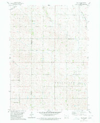
1980 Map of Vail NE
USGS Topo · Published 1980About this map
The Middle Raccoon River and its tributaries, including Lime Creek and Beaman Creek, define the rolling agricultural landscape of this Iowa borderland. Surveyed in the mid-1970s, the map reveals a countryside partitioned by traditional township lines including Viola, Wheatland, Levey, and Jackson. This era shows a transition in rail history, with both the Illinois Central Gulf and Chicago and North Western rail lines traversing the northern reaches of the quadrangle. For those researching local family histories, the map identifies key rural community hubs such as Wheatland Ch Cem, South Wall Lake Cem, and Emmanuel Cem. The inclusion of fine red dashed lines to indicate field fences provides a unique level of detail regarding land use and property boundaries during this period.
Find a feature on this map
18 named features on this map. Tap any name to fly to it.
Don’t see what you’re looking for? This feature index may not catch every label — zoom into the map to look around manually.
Map Details
Editions of this 1980 Vail NE Map
This is the sole edition of this map. No revisions or reprints were ever made.
Other maps of this area

1954 · Fort Dodge
USGS Topo · 1:250,000

1957 · Fort Dodge
USGS Topo · 1:250,000

1958 · Fort Dodge
USGS Topo · 1:250,000

1980 · Odebolt East
USGS Topo · 1:24,000

1980 · Breda
USGS Topo · 1:24,000

1980 · Grant City
USGS Topo · 1:24,000

1980 · Lake View
USGS Topo · 1:24,000

1980 · Boyer
USGS Topo · 1:24,000
1980 · Carroll West
USGS Topo · 1:24,000
1980 · Arcadia
USGS Topo · 1:24,000