
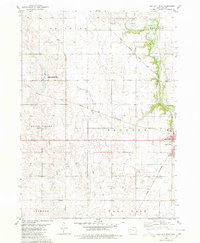
1980 Map of Lake View
USGS Topo · Published 1980About this map
The recreational and agricultural landscape of Sac County centers on Black Hawk Lake, where public lands like the Black Hawk Lake State Recreation Area and Black Hawk Lake State Game Management Area define the shoreline. The town of Lake View sits at the north end of the water, characterized by named points such as Ice House Point and Drillings Point. To the southwest, the community of Wall Lake serves as a secondary hub, located near the Wall Lake Municipal Airport and several industrial Gravel Pits.
Find a feature on this map
38 named features on this map. Tap any name to fly to it.
Don’t see what you’re looking for? This feature index may not catch every label — zoom into the map to look around manually.
Map Details
Editions of this 1980 Lake View Map
This is the sole edition of this map. No revisions or reprints were ever made.
Other maps of this area

1954 · Fort Dodge
USGS Topo · 1:250,000

1957 · Fort Dodge
USGS Topo · 1:250,000

1958 · Fort Dodge
USGS Topo · 1:250,000

1980 · Odebolt East
USGS Topo · 1:24,000

1980 · Sac City East
USGS Topo · 1:24,000

1980 · Breda
USGS Topo · 1:24,000

1980 · Grant City
USGS Topo · 1:24,000

1980 · Early
USGS Topo · 1:24,000
1980 · Sac City West
USGS Topo · 1:24,000

1980 · Boyer
USGS Topo · 1:24,000