
1980 Map of Grant City
USGS Topo · Published 1980About this map
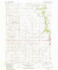
The North Raccoon River carves a serpentine path through the heart of Coon Valley in this 1980 survey of southeastern Sac County. The landscape is defined by the legacy of transit and resource extraction, visible in the numerous Gravel Pits dotting the riverbanks and the industrial presence of the Gulf Central Illinois Railroad near Ulmer. To the south, an Old Railroad Grade runs parallel to the modern tracks, marking a shift in the local transportation network over the decades. The settlement of Grant City sits nestled near the river's bend, adjacent to the preserved grounds of Grant County Park. Rural community life is anchored by several long-standing sites, including St Peters Ch in the northeast and a series of burial grounds such as Emanuel Cem and St Marys Cem, which serve as vital markers for local genealogical research.
Find a feature on this map
18 named features on this map. Tap any name to fly to it.
Don’t see what you’re looking for? This feature index may not catch every label — zoom into the map to look around manually.
Map Details
Editions of this 1980 Grant City Map
This is the sole edition of this map. No revisions or reprints were ever made.
Other maps of this area

1954 · Fort Dodge
USGS Topo · 1:250,000

1957 · Fort Dodge
USGS Topo · 1:250,000

1958 · Fort Dodge
USGS Topo · 1:250,000

1980 · Lytton
USGS Topo · 1:24,000

1980 · Sac City East
USGS Topo · 1:24,000

1980 · Breda
USGS Topo · 1:24,000

1980 · Carroll NE
USGS Topo · 1:24,000

1980 · Yetter
USGS Topo · 1:24,000

1980 · Lake View
USGS Topo · 1:24,000
1980 · Sac City West
USGS Topo · 1:24,000