
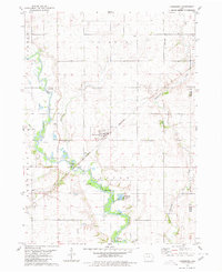
1980 Map of Yetter
USGS Topo · Published 1980About this map
Yetter and the surrounding township of Elm Grove define the agrarian landscape of this Calhoun County study from the late 1970s. The region is characterized by its organized drainage and transport networks, where the Illinois Central Gulf railroad bisects the prairie, connecting small agricultural hubs like Auburn and Lake City. The water system is particularly prominent, featuring the meandering course of the North Raccoon River and its tributaries, Camp Creek and West Fork Camp Creek, which provide natural relief to the gridded farmland.
Find a feature on this map
21 named features on this map. Tap any name to fly to it.
Don’t see what you’re looking for? This feature index may not catch every label — zoom into the map to look around manually.
Map Details
Editions of this 1980 Yetter Map
This is the sole edition of this map. No revisions or reprints were ever made.
Other maps of this area

1954 · Fort Dodge
USGS Topo · 1:250,000

1957 · Fort Dodge
USGS Topo · 1:250,000

1958 · Fort Dodge
USGS Topo · 1:250,000

1980 · Lytton
USGS Topo · 1:24,000

1980 · Rockwell City
USGS Topo · 1:24,000

1980 · Sac City East
USGS Topo · 1:24,000

1980 · Breda
USGS Topo · 1:24,000

1980 · Grant City
USGS Topo · 1:24,000

1980 · Carroll NE
USGS Topo · 1:24,000
1980 · Lanesboro
USGS Topo · 1:24,000