1970s Maps of Delaware County, Iowa
Explore 7 historic maps of Delaware County from the 1970s. These maps offer a rare glimpse into what life looked like during the 1970s — showing old roads, neighborhoods, homes, and landmarks that have changed or disappeared over time.
Whether you're researching your family's past, planning a metal detecting trip, or studying how Delaware County's landscape evolved across the 1970s, these high-resolution maps are a powerful tool for exploring the history of this region.
- Focus on a specific era: All maps on this page are from the 1970s, giving you a focused view of this time period.
- See what’s changed: Compare century-old streets, trails, and buildings to today's modern landscape using overlays and satellite layers.
- Research with precision: Use these maps for genealogy, historical research, land use analysis, or educational projects.
- View, download, or print: Maps are fully viewable online in high resolution, and can be downloaded or printed for your own records.
Start exploring Delaware County's history through authentic maps from the 1970s. This is your window into the past.
Delaware County, IA maps
(7)- 1973 Map of Manchester, 1977 Print
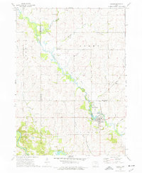
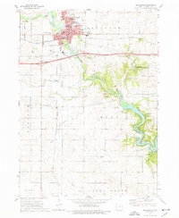 1973 Manchester1977 Print · USGSManchester and the Maquoketa River valley are captured here during the mid-seventies when the regional rail and river networks defined the county's core. Researchers can trace family sites at St Marys Cemetery, Oakland Cemetery, and the Manchester National Fish Hatchery.
 - 1973 Map of Hopkinton West, 1977 Print
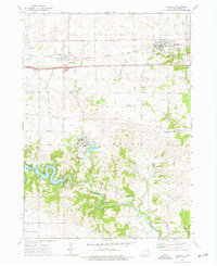
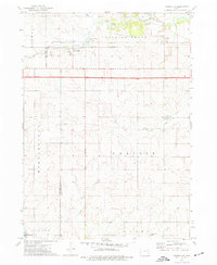
 1973 Hopkinton West1977 Print · USGSDelaware County and its neighboring townships come into focus during the early 1970s as the Maquoketa River valley supports a landscape of small settlements and rail. Trace family roots and land use near Hopkinton, Buck Creek, and the Grove Creek Cem.
 - 1973 Map of Ryan, 1977 Print
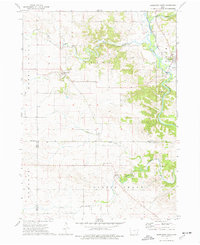
 1973 Ryan1977 Print · USGSThe rural town of Ryan and its surrounding townships are shown here in the early 1970s as the rail and road networks shaped local commerce. Genealogists can trace family landmarks like Golden Ch, Nugents Grove Cem, and the LeClere Landing Strip.
 - 1973 Map of Earlville, 1977 Print
 1973 Earlville1977 Print · USGSEastern Iowa's agricultural heartland is documented here in the early seventies, featuring the small-town hubs of Earlville and Delhi. Genealogists can locate several family burial sites like Pine View Cem and Fairview Cem or trace the early rail corridors of the Illinois Central Gulf.
 - 1973 Map of Masonville, 1977 Print
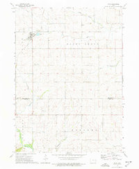
 1973 Masonville1977 Print · USGSMasonville and the surrounding townships appear here in the early 1970s, illustrating the agricultural and rail-based economy of the Delaware-Buchanan county line. Genealogists and local historians can locate early burial sites like Greenwood Cem and St Mary Cem or trace the Illinois Central Gulf railroad corridor.
 - 1973 Map of Coggon, 1977 Print
 1973 Coggon1977 Print · USGSThe agricultural borderlands of Linn and Delaware counties are captured here in the early 1970s. Researchers can trace the path of the Illinois Central Gulf through Coggon or locate family sites like Spring Grove Ch and St Johns Cem.
 - 1976 Map of Dubuque
 1976 Dubuque1976 Print · USGSThe tri-state borderlands of Iowa, Wisconsin, and Illinois come alive during the mid-seventies, showing a region built on river commerce and mining. Genealogists and historians can trace the paths of the Illinois Central railroad or locate heritage sites like the New Melleray Abbey Monastery and Backbone State Park.
End of results
Showing maps 1-7 of 7
Top cities of Delaware County
- Manchester historical maps
- Earlville historical maps
- Hopkinton historical maps
- Delhi historical maps
- Colesburg historical maps
- Ryan historical maps
See more
Frequently asked questions
- What are the different types of historical maps available for Delaware County?
- What is the oldest map of Delaware County?
- Where can I purchase historical maps of Delaware County for my home or office?
- Where can I download high-res historical maps of Delaware County?
- Are there historical topographic maps available for Delaware County?
- Is there historical aerial imagery available for Delaware County?
- Where are historical maps of Delaware County sourced from?