1940s Maps of Des Moines County, Iowa
Explore 5 historic maps of Des Moines County from the 1940s. These maps offer a rare glimpse into what life looked like during the 1940s — showing old roads, neighborhoods, homes, and landmarks that have changed or disappeared over time.
Whether you're researching your family's past, planning a metal detecting trip, or studying how Des Moines County's landscape evolved across the 1940s, these high-resolution maps are a powerful tool for exploring the history of this region.
- Focus on a specific era: All maps on this page are from the 1940s, giving you a focused view of this time period.
- See what’s changed: Compare century-old streets, trails, and buildings to today's modern landscape using overlays and satellite layers.
- Research with precision: Use these maps for genealogy, historical research, land use analysis, or educational projects.
- View, download, or print: Maps are fully viewable online in high resolution, and can be downloaded or printed for your own records.
Start exploring Des Moines County's history through authentic maps from the 1940s. This is your window into the past.
Des Moines County, IA maps
(5)- 1940 Map of Oquawka
 1940 Oquawka1940 Print · USGSHenderson County's river-and-rail economy is captured here during the 1930s as the Mississippi River environment meets an expanding network of rural towns. Genealogists and historians can trace dozens of country schoolhouses and cemeteries, from the Little Brick Sch to South Henderson Cem.2 unique versions available
 - 1940 Map of Burlington
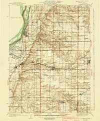
 1940 Burlington1940 Print · USGSThe Mississippi River floodplain comes alive in the mid-1930s, showing the intricate network of sloughs and rail lines between Illinois and Iowa. Genealogists and historians can locate rural landmarks like Merry Dell Sch, trace the Chicago Burlington and Quincy tracks, or explore the riverfront at Gulfport.3 unique versions available
 - 1941 Map of Keithsburg
 1941 Keithsburg1941 Print · USGSThe Mississippi River front in Mercer County thrived during the early 1940s as a hub of rail and river commerce. Genealogists can trace family footprints through dozens of rural landmarks, from Peniel Ch to schoolhouses like Prouty Sch and Lee Sch.2 unique versions available
 - 1946 Map of Wapello, 1954 Print
 1946 Wapello1954 Print · USGSThe riverfront town of New Boston and the surrounding islands are captured in the mid-1940s as the Mississippi River meets the Iowa River. Researchers can trace the era's local rural life at Swan Lake Sch, Pin Oak Sch, and the engineering at Lock and Dam No 17.2 unique versions available
 - 1949 Map of Wapello
 1949 Wapello1949 Print · USGSThe riverfront of Mercer County and the Mississippi border appear here in the late 1940s, just after the war. Local historians can trace the river's path through Lock and Dam No 17, find rural schoolhouses like Bay View Sch, or locate the Ferry at the mouth of the Iowa River.2 unique versions available
End of results
Showing maps 1-5 of 5
Top cities of Des Moines County
- Burlington historical maps
- West Burlington historical maps
- Mediapolis historical maps
- Danville historical maps
- Beaverdale historical maps
- Middletown historical maps
Frequently asked questions
- What are the different types of historical maps available for Des Moines County?
- What is the oldest map of Des Moines County?
- Where can I purchase historical maps of Des Moines County for my home or office?
- Where can I download high-res historical maps of Des Moines County?
- Are there historical topographic maps available for Des Moines County?
- Is there historical aerial imagery available for Des Moines County?
- Where are historical maps of Des Moines County sourced from?