1980s Maps of Yarmouth, Iowa
Explore 2 historic maps of Yarmouth from the 1980s. These maps offer a rare glimpse into what life looked like during the 1980s — showing old roads, neighborhoods, homes, and landmarks that have changed or disappeared over time.
Whether you're researching your family's past, planning a metal detecting trip, or studying how Yarmouth's landscape evolved across the 1980s, these high-resolution maps are a powerful tool for exploring the history of this region.
- Focus on a specific era: All maps on this page are from the 1980s, giving you a focused view of this time period.
- See what’s changed: Compare century-old streets, trails, and buildings to today's modern landscape using overlays and satellite layers.
- Research with precision: Use these maps for genealogy, historical research, land use analysis, or educational projects.
- View, download, or print: Maps are fully viewable online in high resolution, and can be downloaded or printed for your own records.
Start exploring Yarmouth's history through authentic maps from the 1980s. This is your window into the past.
Yarmouth, IA maps
(2)- 1981 Map of Morning Sun
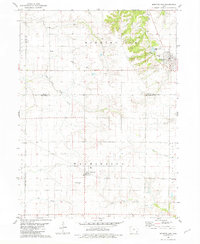 1981 Morning Sun1981 Print · USGSMorning Sun and Yarmouth appear here in the early 1980s, illustrating the agricultural and civic layout of the Louisa and Des Moines county border. Genealogists can locate family sites like Elmwood Cem and Rice Cem or trace the paths of East Fork Crooked Creek and Flint Creek.
 - 1984 Map of Muscatine, 1985 Print
 1984 Muscatine1985 Print · USGSThe Mississippi River corridor and Iowa prairie meet in the 1980s, showcasing a landscape of river navigation and agricultural heartland. Genealogists and researchers can locate old schools and landmarks like Maharishi International University, Elm Grove Cem, and Lock & Dam No 16.2 unique versions available
End of results
Showing maps 1-2 of 2
Top cities near Yarmouth
- Burlington historical maps
- Mount Pleasant historical maps
- West Burlington historical maps
- Wapello historical maps
- New London historical maps
- Mediapolis historical maps
See more
Frequently asked questions
- What are the different types of historical maps available for Yarmouth?
- What is the oldest map of Yarmouth?
- Where can I purchase historical maps of Yarmouth for my home or office?
- Where can I download high-res historical maps of Yarmouth?
- Are there historical topographic maps available for Yarmouth?
- Is there historical aerial imagery available for Yarmouth?
- Where are historical maps of Yarmouth sourced from?