1980s Maps of Junction Township, Iowa
Explore 6 historic maps of Junction Township from the 1980s. These maps offer a rare glimpse into what life looked like during the 1980s — showing old roads, neighborhoods, homes, and landmarks that have changed or disappeared over time.
Whether you're researching your family's past, planning a metal detecting trip, or studying how Junction Township's landscape evolved across the 1980s, these high-resolution maps are a powerful tool for exploring the history of this region.
- Focus on a specific era: All maps on this page are from the 1980s, giving you a focused view of this time period.
- See what’s changed: Compare century-old streets, trails, and buildings to today's modern landscape using overlays and satellite layers.
- Research with precision: Use these maps for genealogy, historical research, land use analysis, or educational projects.
- View, download, or print: Maps are fully viewable online in high resolution, and can be downloaded or printed for your own records.
Start exploring Junction Township's history through authentic maps from the 1980s. This is your window into the past.
Junction Township, IA maps
(6)- 1982 Map of Rippey, 1983 Print
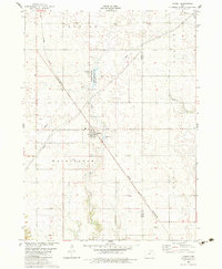 1982 Rippey1983 Print · USGSRippey and the surrounding Iowa farmland are documented here in the early eighties at a significant rail crossroads. Genealogists and local historians can trace the paths of the Chicago and North Western railroad or locate sites like the cemetery and Angus.
 - 1982 Map of Grand Junction, 1983 Print
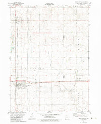 1982 Grand Junction1983 Print · USGSGrand Junction and its surrounding townships are shown here in the early eighties, centered on the critical rail crossing and local agricultural hubs. Researchers can trace family roots at Mount Calvary Cem or locate the rural siding at Dana and the settlement of Beaver.
 - 1982 Map of Cooper, 1983 Print
 1982 Cooper1983 Print · USGSGreene County farmland meets the wooded valley of the North Raccoon River in the early eighties. Genealogists and local researchers can trace the Chicago and North Western rail corridor through Cooper or locate several burial sites like Old Rippey Cem and Franklin Cem.
 - 1984 Map of Guthrie Center, 1985 Print
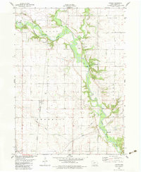
 1984 Guthrie Center1985 Print · USGSWest-central Iowa's river valleys and farming townships are shown here in the mid-1980s, highlighting a network of conservation areas and historic rail towns. Genealogists and local historians can locate Violet Hill Cem, trace the Chicago and North Western railroad, or explore the grounds of Springbrook State Park.
 - 1985 Map of Carroll
 1985 Carroll1985 Print · USGSWest-Central Iowa in the mid-eighties shows a landscape of highly engineered farmland and river-valley conservation. Researchers can trace the drainage patterns of Purgatory Creek or locate local landmarks like Dolliver Memorial State Park and the rail-junction town of Gowrie.
 - 1986 Map of Jefferson East
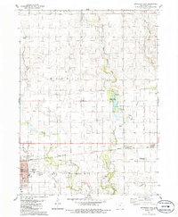 1986 Jefferson East1986 Print · USGSJefferson and the surrounding Greene County townships are captured here in the mid-1980s as the rail-and-road network matured. Genealogists can trace family connections at the Jefferson Cem or follow the Chicago and North Western line to Spring Lake County Park.
End of results
Showing maps 1-6 of 6
Top cities near Junction Township
- Perry historical maps
- Jefferson historical maps
- Ogden historical maps
- Gowrie historical maps
- Dayton historical maps
- Grand Junction historical maps
See more
Top neighborhoods of Junction Township
Frequently asked questions
- What are the different types of historical maps available for Junction Township?
- What is the oldest map of Junction Township?
- Where can I purchase historical maps of Junction Township for my home or office?
- Where can I download high-res historical maps of Junction Township?
- Are there historical topographic maps available for Junction Township?
- Is there historical aerial imagery available for Junction Township?
- Where are historical maps of Junction Township sourced from?