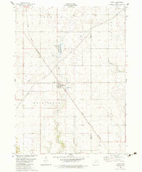
1982 Map of Rippey
USGS Topo · Published 1983About this map
Rippey sits at a diagonal rail junction in Greene County, where the Chicago and North Western line cuts across a landscape defined by prairie drainage and township boundaries. The map illustrates the convergence of several waterways, including the winding Beaver Creek and Snake Creek, the latter of which feeds into the Snake Creek State Game Management Area. This 1982 survey captures the rural character of the region during a period of agricultural stability, showing the layout of small settlements like Angus at the southern edge. Researchers will find interest in the precise placement of local landmarks such as the village park, a secluded cemetery, and the network of industrial pipelines that traverse the township lines of Washington, Junction, and Union.
Find a feature on this map
18 named features on this map. Tap any name to fly to it.
Don’t see what you’re looking for? This feature index may not catch every label — zoom into the map to look around manually.
Map Details
Editions of this 1982 Rippey Map
This is the sole edition of this map. No revisions or reprints were ever made.
Other maps of this area

1950 · Perry
USGS Topo · 1:62,500

1951 · Perry
USGS Topo · 1:62,500

1951 · Ogden
USGS Topo · 1:62,500

1954 · Bagley
USGS Topo · 1:62,500

1954 · Omaha
USGS Topo · 1:250,000

1954 · Fort Dodge
USGS Topo · 1:250,000

1957 · Omaha
USGS Topo · 1:250,000

1957 · Fort Dodge
USGS Topo · 1:250,000

1958 · Omaha
USGS Topo · 1:250,000

1958 · Fort Dodge
USGS Topo · 1:250,000