1970s Maps of Blairsburg Township, Iowa
Explore 4 historic maps of Blairsburg Township from the 1970s. These maps offer a rare glimpse into what life looked like during the 1970s — showing old roads, neighborhoods, homes, and landmarks that have changed or disappeared over time.
Whether you're researching your family's past, planning a metal detecting trip, or studying how Blairsburg Township's landscape evolved across the 1970s, these high-resolution maps are a powerful tool for exploring the history of this region.
- Focus on a specific era: All maps on this page are from the 1970s, giving you a focused view of this time period.
- See what’s changed: Compare century-old streets, trails, and buildings to today's modern landscape using overlays and satellite layers.
- Research with precision: Use these maps for genealogy, historical research, land use analysis, or educational projects.
- View, download, or print: Maps are fully viewable online in high resolution, and can be downloaded or printed for your own records.
Start exploring Blairsburg Township's history through authentic maps from the 1970s. This is your window into the past.
Blairsburg Township, IA maps
(4)- 1978 Map of Blairsburg, 1979 Print
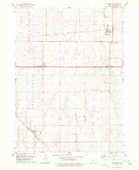 1978 Blairsburg1979 Print · USGSHamilton County agriculture and rail systems are clearly defined in the late seventies. Family historians can locate specific landmarks like Blairsburg Cem, First United Ch, and the rail junction at Kamrar as they appeared decades ago.
 - 1978 Map of Sheldon Creek, 1979 Print
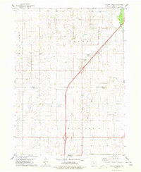 1978 Sheldon Creek1979 Print · USGSThe Wright and Hamilton County borderland is captured in the late 1970s, showcasing a landscape of prairie agriculture and managed waterways. Genealogists and researchers can locate the Vernon Ch, a rural Townhall, and the expansive Wall Lake.
 - 1978 Map of Clarion SW, 1979 Print
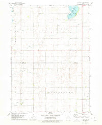 1978 Clarion SW1979 Print · USGSWright and Hamilton Counties in the late seventies showcase a landscape of managed waterways and glacial lakes. Genealogists and local historians can trace rural landmarks like the United Ch and Townhall, or locate the Boat Ramp at Big Wall Lake.
 - 1978 Map of Williams, 1979 Print
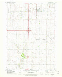 1978 Williams1979 Print · USGSHamilton County in the late seventies is marked by the massive intersection of major interstates amidst a traditional farming landscape. Genealogists and historians can locate the St Marys Cem, trace the Illinois Central Gulf rail line, and find the Community Hall.
End of results
Showing maps 1-4 of 4
Top cities near Blairsburg Township
- Webster City historical maps
- Eagle Grove historical maps
- Clarion historical maps
- Jewell historical maps
- Jewell Junction historical maps
- Dows historical maps
See more
Top neighborhoods of Blairsburg Township
Frequently asked questions
- What are the different types of historical maps available for Blairsburg Township?
- What is the oldest map of Blairsburg Township?
- Where can I purchase historical maps of Blairsburg Township for my home or office?
- Where can I download high-res historical maps of Blairsburg Township?
- Are there historical topographic maps available for Blairsburg Township?
- Is there historical aerial imagery available for Blairsburg Township?
- Where are historical maps of Blairsburg Township sourced from?