1970s Maps of Ellsworth Township, Iowa
Explore 4 historic maps of Ellsworth Township from the 1970s. These maps offer a rare glimpse into what life looked like during the 1970s — showing old roads, neighborhoods, homes, and landmarks that have changed or disappeared over time.
Whether you're researching your family's past, planning a metal detecting trip, or studying how Ellsworth Township's landscape evolved across the 1970s, these high-resolution maps are a powerful tool for exploring the history of this region.
- Focus on a specific era: All maps on this page are from the 1970s, giving you a focused view of this time period.
- See what’s changed: Compare century-old streets, trails, and buildings to today's modern landscape using overlays and satellite layers.
- Research with precision: Use these maps for genealogy, historical research, land use analysis, or educational projects.
- View, download, or print: Maps are fully viewable online in high resolution, and can be downloaded or printed for your own records.
Start exploring Ellsworth Township's history through authentic maps from the 1970s. This is your window into the past.
Ellsworth Township, IA maps
(4)- 1975 Map of Ames NW, 1978 Print
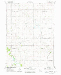 1975 Ames NW1978 Print · USGSThe intersection of Hamilton and Story counties is captured here in the mid-seventies, showing a landscape of fertile township sections and stream valleys. Genealogists can trace family heritage at SS Peter & Paul Cem or Center Cem, and locate the old Chicago and North Western rail line.
 - 1975 Map of Story City, 1978 Print
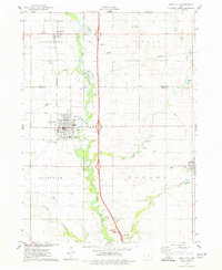 1975 Story City1978 Print · USGSStory City and its neighboring prairie townships are captured here in the mid-seventies as the regional rail and river network shaped local life. Researchers can trace family sites at Mt Olive Cem, follow the Chicago and North Western tracks, or locate the Old Railroad Grade near Roland.
 - 1978 Map of Ellsworth, 1979 Print
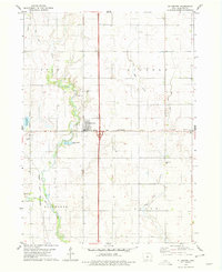 1978 Ellsworth1979 Print · USGSHamilton County farmland meets the river and rail lines of the late seventies, centered on the growing community of Ellsworth. Genealogists and local historians can trace family locations near Homewood Cem or follow the path of the CHICAGO AND NORTH WESTERN railroad along the South Skunk River.
 - 1978 Map of Jewell, 1979 Print
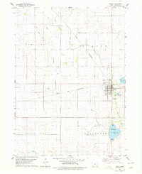 1978 Jewell1979 Print · USGSJewell and the surrounding Hamilton County townships are shown in detail during the late seventies. Genealogists and local historians can trace the town's footprint from Evergreen Cem to the Chicago and North Western rail lines and Little Wall Lake.
End of results
Showing maps 1-4 of 4
Top cities near Ellsworth Township
- Ames historical maps
- Boone historical maps
- Webster City historical maps
- Nevada historical maps
- Story City historical maps
- Roland historical maps
See more
Top neighborhoods of Ellsworth Township
Frequently asked questions
- What are the different types of historical maps available for Ellsworth Township?
- What is the oldest map of Ellsworth Township?
- Where can I purchase historical maps of Ellsworth Township for my home or office?
- Where can I download high-res historical maps of Ellsworth Township?
- Are there historical topographic maps available for Ellsworth Township?
- Is there historical aerial imagery available for Ellsworth Township?
- Where are historical maps of Ellsworth Township sourced from?