1970s Maps of Modale, Iowa
Explore 2 historic maps of Modale from the 1970s. These maps offer a rare glimpse into what life looked like during the 1970s — showing old roads, neighborhoods, homes, and landmarks that have changed or disappeared over time.
Whether you're researching your family's past, planning a metal detecting trip, or studying how Modale's landscape evolved across the 1970s, these high-resolution maps are a powerful tool for exploring the history of this region.
- Focus on a specific era: All maps on this page are from the 1970s, giving you a focused view of this time period.
- See what’s changed: Compare century-old streets, trails, and buildings to today's modern landscape using overlays and satellite layers.
- Research with precision: Use these maps for genealogy, historical research, land use analysis, or educational projects.
- View, download, or print: Maps are fully viewable online in high resolution, and can be downloaded or printed for your own records.
Start exploring Modale's history through authentic maps from the 1970s. This is your window into the past.
Modale, IA maps
(2)- 1970 Map of Mondamin, 1972 Print
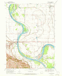
 1970 Mondamin1972 Print · USGSThe Missouri River floodplain of western Iowa is captured here in the early seventies, showing a landscape of managed drainage and rail transit. Genealogists and researchers can trace the roads around Mondamin, find the Noyes Cem, and explore the marshes of Round Lake.
 - 1970 Map of Modale, 1972 Print
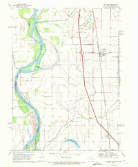
 1970 Modale1972 Print · USGSThe Missouri River floodplain on the Iowa-Nebraska border comes alive in this early 1970s survey. Researchers can trace river changes at De Soto Lake and locate local landmarks like the Fort Calhoun Powerplant and Blair Cem.2 unique versions available
End of results
Showing maps 1-2 of 2
Top cities near Modale
- Blair historical maps
- Missouri Valley historical maps
- Tekamah historical maps
- Logan historical maps
- Fort Calhoun historical maps
- Arizona historical maps
See more
Frequently asked questions
- What are the different types of historical maps available for Modale?
- What is the oldest map of Modale?
- Where can I purchase historical maps of Modale for my home or office?
- Where can I download high-res historical maps of Modale?
- Are there historical topographic maps available for Modale?
- Is there historical aerial imagery available for Modale?
- Where are historical maps of Modale sourced from?