1960s Maps of Chester, Iowa
Explore 2 historic maps of Chester from the 1960s. These maps offer a rare glimpse into what life looked like during the 1960s — showing old roads, neighborhoods, homes, and landmarks that have changed or disappeared over time.
Whether you're researching your family's past, planning a metal detecting trip, or studying how Chester's landscape evolved across the 1960s, these high-resolution maps are a powerful tool for exploring the history of this region.
- Focus on a specific era: All maps on this page are from the 1960s, giving you a focused view of this time period.
- See what’s changed: Compare century-old streets, trails, and buildings to today's modern landscape using overlays and satellite layers.
- Research with precision: Use these maps for genealogy, historical research, land use analysis, or educational projects.
- View, download, or print: Maps are fully viewable online in high resolution, and can be downloaded or printed for your own records.
Start exploring Chester's history through authentic maps from the 1960s. This is your window into the past.
Chester, IA maps
(2)- 1965 Map of Ostrander, 1966 Print
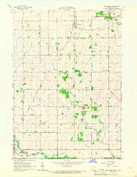 1965 Ostrander1966 Print · USGSThe borderlands of Fillmore County and Iowa are captured here in the mid-sixties, dominated by rail lines and winding river branches. Researchers can pinpoint early landmarks like Bloomfield Cem, the Ostrander rail corridor, and various Quarry sites.
 - 1965 Map of Cherry Grove, 1967 Print
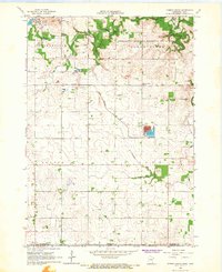 1965 Cherry Grove1967 Print · USGSSouthern Minnesota farmland meets the deep valleys of the Root River in the mid-sixties, just as local strip mines and gravel pits dotted the landscape. Researchers can locate the Chicago Great Western rail line and family landmarks like Bethlehem Cem and Pietenpol Landing Field.
End of results
Showing maps 1-2 of 2
Top cities near Chester
- Cresco historical maps
- Spring Valley historical maps
- Grand Meadow historical maps
- Le Roy historical maps
- Riceville historical maps
- Bristol historical maps
See more
Frequently asked questions
- What are the different types of historical maps available for Chester?
- What is the oldest map of Chester?
- Where can I purchase historical maps of Chester for my home or office?
- Where can I download high-res historical maps of Chester?
- Are there historical topographic maps available for Chester?
- Is there historical aerial imagery available for Chester?
- Where are historical maps of Chester sourced from?