1960s Maps of Ida County, Iowa
Explore 10 historic maps of Ida County from the 1960s. These maps offer a rare glimpse into what life looked like during the 1960s — showing old roads, neighborhoods, homes, and landmarks that have changed or disappeared over time.
Whether you're researching your family's past, planning a metal detecting trip, or studying how Ida County's landscape evolved across the 1960s, these high-resolution maps are a powerful tool for exploring the history of this region.
- Focus on a specific era: All maps on this page are from the 1960s, giving you a focused view of this time period.
- See what’s changed: Compare century-old streets, trails, and buildings to today's modern landscape using overlays and satellite layers.
- Research with precision: Use these maps for genealogy, historical research, land use analysis, or educational projects.
- View, download, or print: Maps are fully viewable online in high resolution, and can be downloaded or printed for your own records.
Start exploring Ida County's history through authentic maps from the 1960s. This is your window into the past.
Ida County, IA maps
(10)- 1967 Map of Holstein, 1968 Print
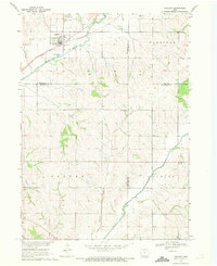
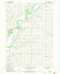
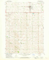 1967 Holstein1968 Print · USGSIda County farming country and the town of Holstein are shown in detail during the late 1960s. Genealogists and local historians can trace the paths of the Chicago and North Western Railroad Grade and locate the Norwegian Cem or Battle Center Ch.
 - 1967 Map of Ida Grove, 1968 Print
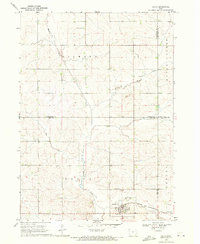
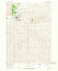 1967 Ida Grove1968 Print · USGSIda Grove in the late 1960s is shown as a thriving river town at the junction of the Maple River and Odebolt Creek. Researchers can trace the town's industrial and social heart through the Chicago and North Western rail line, Moorehead Pioneer Park, and local sites like the Sacred Heart Cem.
 - 1967 Map of Battle Creek, 1968 Print
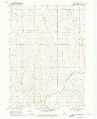
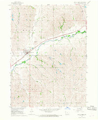 1967 Battle Creek1968 Print · USGSThe Maple River valley in the late 1960s shows a well-connected agricultural hub centered on the town of Battle Creek. Genealogists and local historians can trace family-named sites like Nicholson Field, the grounds of Mount Hope Cem, and the path of the Chicago and North Western railroad.2 unique versions available
 - 1967 Map of Ida Grove NW, 1968 Print
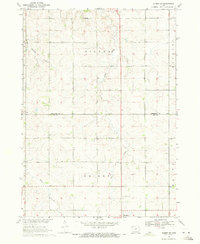
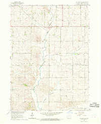 1967 Ida Grove NW1968 Print · USGSAgricultural life in rural Ida County during the late sixties is defined by its creek valleys and the Chicago and North Western rail line. Researchers can locate the Silver Creek Ch, the local Townhall, and mid-century property fence lines.
 - 1969 Map of Danbury, 1971 Print
 1969 Danbury1971 Print · USGSDanbury and the surrounding river valleys are captured here in the late sixties as the rail-and-river economy shaped Woodbury County. Researchers can locate several burial grounds including St Marys Cem and Hartleben Cem, or trace the Chicago and North Western line.2 unique versions available
 - 1969 Map of Holstein SW, 1971 Print
 1969 Holstein SW1971 Print · USGSWoodbury and Ida Counties are captured here in the late sixties, showing a landscape shaped by the Maple River and the rural townships. Genealogists can locate St Pauls Ch and St Marys Cem, or trace the Chicago and North Western rail line.2 unique versions available
 - 1969 Map of Galva, 1971 Print
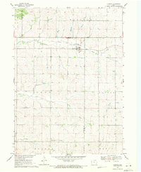
 1969 Galva1971 Print · USGSAgricultural life in Ida County centered on Galva during the late sixties, where the railroad and river valleys shaped the local landscape. Genealogists and researchers can locate family plots at Diamond Cem or trace the course of the Chicago and North Western line.
 - 1969 Map of Cushing, 1971 Print
 1969 Cushing1971 Print · USGSCushing and the surrounding Woodbury County townships are shown in the late 1960s as the regional rail economy shifted. Genealogists and local historians can trace family plots at Cushing Cem or follow the path of the Old Railroad Grade.
 - 1969 Map of Quimby SE, 1971 Print
 1969 Quimby SE1971 Print · USGSNorthwestern Iowa farmland at the end of the 1960s reveals a landscape of rural sections and expanding towns. Genealogists can trace family land across Griggs township and locate the Silver Cem and Holstein Cem near the town of Holstein.
 - 1969 Map of Washta, 1971 Print
 1969 Washta1971 Print · USGSThe Little Sioux River valley in northwestern Iowa is captured here in the late sixties, showing a landscape of river-bend parks and rail-connected towns. Researchers can trace family sites at Sunset View Cem, find the old Willow Sch, or follow the Illinois Central through Washta.
End of results
Showing maps 1-10 of 10
Top cities of Ida County
- Ida Grove historical maps
- Holstein historical maps
- Battle Creek historical maps
- Galva historical maps
- Arthur historical maps
Frequently asked questions
- What are the different types of historical maps available for Ida County?
- What is the oldest map of Ida County?
- Where can I purchase historical maps of Ida County for my home or office?
- Where can I download high-res historical maps of Ida County?
- Are there historical topographic maps available for Ida County?
- Is there historical aerial imagery available for Ida County?
- Where are historical maps of Ida County sourced from?