1970s Maps of Iowa County, Iowa
Explore 4 historic maps of Iowa County from the 1970s. These maps offer a rare glimpse into what life looked like during the 1970s — showing old roads, neighborhoods, homes, and landmarks that have changed or disappeared over time.
Whether you're researching your family's past, planning a metal detecting trip, or studying how Iowa County's landscape evolved across the 1970s, these high-resolution maps are a powerful tool for exploring the history of this region.
- Focus on a specific era: All maps on this page are from the 1970s, giving you a focused view of this time period.
- See what’s changed: Compare century-old streets, trails, and buildings to today's modern landscape using overlays and satellite layers.
- Research with precision: Use these maps for genealogy, historical research, land use analysis, or educational projects.
- View, download, or print: Maps are fully viewable online in high resolution, and can be downloaded or printed for your own records.
Start exploring Iowa County's history through authentic maps from the 1970s. This is your window into the past.
Iowa County, IA maps
(4)- 1973 Map of Oxford, 1975 Print
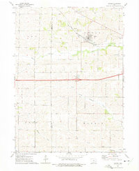 1973 Oxford1975 Print · USGSOxford and its surrounding Iowa townships are caught here in the early 1970s, as the landscape balanced rail-era roots with modern highway expansion. Trace local family history at Oxford Cem or follow the path of the CHICAGO ROCK ISLAND AND PACIFIC railroad.
 - 1973 Map of Amish, 1975 Print
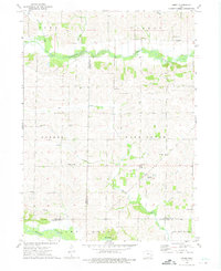 1973 Amish1975 Print · USGSIowa's rural heritage is preserved in this mid-1970s survey of the Johnson and Washington county borders. Genealogists and local historians can trace the foundations of this community through the Mennonite Sch, Windham cemetery, and Amish settlement.
 - 1973 Map of Conroy, 1975 Print
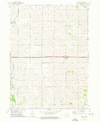 1973 Conroy1975 Print · USGSIowa County at the start of the 1970s shows a landscape of established farmsteads and rural parish life. Genealogists and local historians can trace family roots through numerous sites like Trinity Cem, Dane Cem, and the village of Williamsburg.
 - 1973 Map of Holbrook, 1975 Print
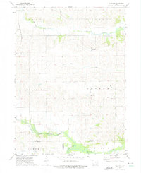 1973 Holbrook1975 Print · USGSIowa County farmland in the early 1970s reveals a quiet landscape shaped by the North English River and the legacy of local settlements. Genealogists can trace family roots through several rural burial grounds, including St Josephs Cem, Piersol Cem, and the community of Holbrook.
End of results
Showing maps 1-4 of 4
Top cities of Iowa County
- Williamsburg historical maps
- Marengo historical maps
- North English historical maps
- Victor historical maps
- Middle Amana historical maps
- Amana historical maps
See more
Frequently asked questions
- What are the different types of historical maps available for Iowa County?
- What is the oldest map of Iowa County?
- Where can I purchase historical maps of Iowa County for my home or office?
- Where can I download high-res historical maps of Iowa County?
- Are there historical topographic maps available for Iowa County?
- Is there historical aerial imagery available for Iowa County?
- Where are historical maps of Iowa County sourced from?