1970s Maps of Jasper County, Iowa
Explore 5 historic maps of Jasper County from the 1970s. These maps offer a rare glimpse into what life looked like during the 1970s — showing old roads, neighborhoods, homes, and landmarks that have changed or disappeared over time.
Whether you're researching your family's past, planning a metal detecting trip, or studying how Jasper County's landscape evolved across the 1970s, these high-resolution maps are a powerful tool for exploring the history of this region.
- Focus on a specific era: All maps on this page are from the 1970s, giving you a focused view of this time period.
- See what’s changed: Compare century-old streets, trails, and buildings to today's modern landscape using overlays and satellite layers.
- Research with precision: Use these maps for genealogy, historical research, land use analysis, or educational projects.
- View, download, or print: Maps are fully viewable online in high resolution, and can be downloaded or printed for your own records.
Start exploring Jasper County's history through authentic maps from the 1970s. This is your window into the past.
Jasper County, IA maps
(5)- 1972 Map of Runnells, 1974 Print
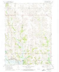 1972 Runnells1974 Print · USGSRunnells and the southern Polk County borderlands are shown here in the early seventies, just as the regional landscape was adjusting to the presence of Lake Red Rock. Researchers can trace old family sites and rural infrastructure through the Vandalia Cem, the Runnells Sch, and the Norfolk and Western rail line.
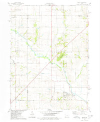
 - 1972 Map of Mitchellville, 1974 Print
 1972 Mitchellville1974 Print · USGSAcross the Polk and Jasper County line in the early 1970s, this area shows a landscape defined by rail corridors and the meandering South Skunk River. Genealogists can locate family landmarks like Sams Cem and Fisher Cem or trace the small-town footprints of Valeria and Mitchellville.
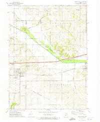
 - 1975 Map of Mingo, 1978 Print
 1975 Mingo1978 Print · USGSMid-Iowa's agricultural landscape comes into focus during the 1970s at the junction of Story, Jasper, and Polk counties. Researchers can trace rural genealogy and transport through Mingo, the Old RR Grade at Farrar, and local landmarks like Ashton Ch and Deeter Cem.
 - 1975 Map of Baxter, 1978 Print
 1975 Baxter1978 Print · USGSThe town of Baxter and its surrounding townships are shown here during the mid-1970s, capturing the organized grid of Iowa's agricultural heartland. Genealogists and local historians can locate several rural burial grounds, including Restland Cem and Independence Cem, alongside the CHICAGO AND NORTH WESTERN rail line.
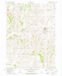
 - 1975 Map of Baxter SE, 1978 Print
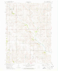 1975 Baxter SE1978 Print · USGSJasper County farmland in the mid-1970s is defined by the winding North Skunk River and a network of rural townships. Genealogists and local historians can locate several family burial grounds including Bethany Cem and the Wittenberg Grange Hall.
End of results
Showing maps 1-5 of 5
Top cities of Jasper County
Frequently asked questions
- What are the different types of historical maps available for Jasper County?
- What is the oldest map of Jasper County?
- Where can I purchase historical maps of Jasper County for my home or office?
- Where can I download high-res historical maps of Jasper County?
- Are there historical topographic maps available for Jasper County?
- Is there historical aerial imagery available for Jasper County?
- Where are historical maps of Jasper County sourced from?