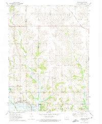
1972 Map of Runnells
USGS Topo · Published 1974About this map
Runnells and the nearby hamlet of Vandalia anchor this 1970s landscape at the junction of Polk and Jasper Counties. The terrain is defined by the expansive waters of Lake Red Rock and Howard Lake to the south, while the northern sections are carved by the winding paths of Camp Creek and Walnut Creek. This period shows the transition of the Des Moines River valley before modern development fully altered the rural character of southeastern Polk County.
Find a feature on this map
32 named features on this map. Tap any name to fly to it.
Don’t see what you’re looking for? This feature index may not catch every label — zoom into the map to look around manually.
Map Details
Editions of this 1972 Runnells Map
This is the sole edition of this map. No revisions or reprints were ever made.
Other maps of this area

1909 · Knoxville
USGS Topo · 1:62,500

1910 · Milo
USGS Topo · 1:62,500

1912 · Knoxville
USGS Topo · 1:62,500

1930 · Mitchellville
USGS Topo · 1:62,500

1954 · Des Moines
USGS Topo · 1:250,000

1956 · Des Moines
USGS Topo · 1:250,000

1957 · Des Moines
USGS Topo · 1:250,000

1965 · Pleasantville
USGS Topo · 1:24,000

1965 · Prairie City
USGS Topo · 1:24,000

1965 · Knoxville NW
USGS Topo · 1:24,000