1960s Maps of Hayesville, Iowa
Explore 3 historic maps of Hayesville from the 1960s. These maps offer a rare glimpse into what life looked like during the 1960s — showing old roads, neighborhoods, homes, and landmarks that have changed or disappeared over time.
Whether you're researching your family's past, planning a metal detecting trip, or studying how Hayesville's landscape evolved across the 1960s, these high-resolution maps are a powerful tool for exploring the history of this region.
- Focus on a specific era: All maps on this page are from the 1960s, giving you a focused view of this time period.
- See what’s changed: Compare century-old streets, trails, and buildings to today's modern landscape using overlays and satellite layers.
- Research with precision: Use these maps for genealogy, historical research, land use analysis, or educational projects.
- View, download, or print: Maps are fully viewable online in high resolution, and can be downloaded or printed for your own records.
Start exploring Hayesville's history through authentic maps from the 1960s. This is your window into the past.
Hayesville, IA maps
(3)- 1965 Map of Sigourney, 1966 Print
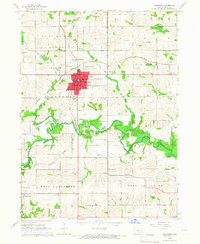 1965 Sigourney1966 Print · USGSSigourney and the surrounding Iowa countryside are captured here in the mid-1960s, showing a landscape defined by rail lines and river valleys. Genealogists can trace family names at Pennington Cem or Conner Cem and locate landmarks like the County Farm.
 - 1965 Map of Delta, 1966 Print
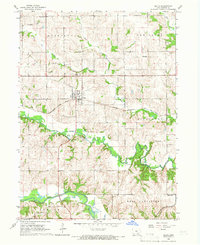 1965 Delta1966 Print · USGSDelta and the Skunk River valleys are captured here in the mid-sixties, showing a landscape of coal mines, quarries, and small-town rail commerce. Researchers can locate several family burial grounds like Garrett Cem and landmarks such as the Covered Bridge.
 - 1969 Map of Des Moines
 1969 Des Moines1969 Print · USGSCentral Iowa's fertile plains and growing capital are captured here during the late sixties, a time of major highway expansion and reservoir construction. Genealogists and researchers can trace rural township boundaries, local cemeteries, and rail lines serving towns like Pella, Grinnell, and Oskaloosa.
End of results
Showing maps 1-3 of 3
Top cities near Hayesville
- Ottumwa historical maps
- Sigourney historical maps
- Hedrick historical maps
- Fremont historical maps
- What Cheer historical maps
- Maharishi Vedic City historical maps
See more
Frequently asked questions
- What are the different types of historical maps available for Hayesville?
- What is the oldest map of Hayesville?
- Where can I purchase historical maps of Hayesville for my home or office?
- Where can I download high-res historical maps of Hayesville?
- Are there historical topographic maps available for Hayesville?
- Is there historical aerial imagery available for Hayesville?
- Where are historical maps of Hayesville sourced from?