1960s Maps of Kossuth County, Iowa
Explore 4 historic maps of Kossuth County from the 1960s. These maps offer a rare glimpse into what life looked like during the 1960s — showing old roads, neighborhoods, homes, and landmarks that have changed or disappeared over time.
Whether you're researching your family's past, planning a metal detecting trip, or studying how Kossuth County's landscape evolved across the 1960s, these high-resolution maps are a powerful tool for exploring the history of this region.
- Focus on a specific era: All maps on this page are from the 1960s, giving you a focused view of this time period.
- See what’s changed: Compare century-old streets, trails, and buildings to today's modern landscape using overlays and satellite layers.
- Research with precision: Use these maps for genealogy, historical research, land use analysis, or educational projects.
- View, download, or print: Maps are fully viewable online in high resolution, and can be downloaded or printed for your own records.
Start exploring Kossuth County's history through authentic maps from the 1960s. This is your window into the past.
Kossuth County, IA maps
(4)- 1967 Map of Pilot Grove, 1968 Print
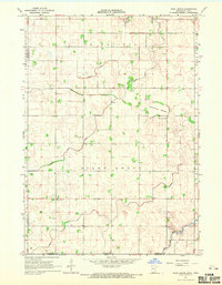 1967 Pilot Grove1968 Print · USGSFaribault County agriculture and water management are on full display in this late-sixties survey of the Minnesota-Iowa border. Genealogists and researchers can locate the Pilot Grove Cemetery, the local Townhall, and the winding West Branch Blue Earth River.
 - 1967 Map of East Chain, 1968 Print
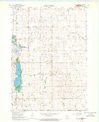 1967 East Chain1968 Print · USGSSouthern Martin County at the Minnesota-Iowa border reveals a landscape of prairie drainage and rural community in the late sixties. Genealogists and local historians can trace family locations near East Chain Ch, St Pauls Ch, or the Evangelical Cem.
 - 1967 Map of Wilmert Lake, 1968 Print
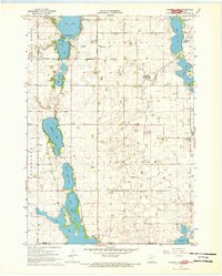 1967 Wilmert Lake1968 Print · USGSThe Minnesota-Iowa borderlands are captured here in the late sixties, showcasing the intricate chain of lakes and agricultural drainage networks. Genealogists can trace family locations near Oakwood Cem, Center Chain Cem, or the Amber Lake Park area.2 unique versions available
 - 1967 Map of Elmore, 1968 Print
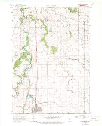 1967 Elmore1968 Print · USGSFaribault County and the Iowa borderlands come to life in the late sixties as agricultural patterns and rail lines define the prairie. Genealogists and local historians can trace rural landmarks like St Johns Ch, Dobson Cem, and the old Marna station site.
End of results
Showing maps 1-4 of 4
Top cities of Kossuth County
- Algona historical maps
- Bancroft historical maps
- Swea City historical maps
- Titonka historical maps
- Whittemore historical maps
- Burt historical maps
See more
Frequently asked questions
- What are the different types of historical maps available for Kossuth County?
- What is the oldest map of Kossuth County?
- Where can I purchase historical maps of Kossuth County for my home or office?
- Where can I download high-res historical maps of Kossuth County?
- Are there historical topographic maps available for Kossuth County?
- Is there historical aerial imagery available for Kossuth County?
- Where are historical maps of Kossuth County sourced from?