1970s Maps of Wesley, Iowa
Explore 2 historic maps of Wesley from the 1970s. These maps offer a rare glimpse into what life looked like during the 1970s — showing old roads, neighborhoods, homes, and landmarks that have changed or disappeared over time.
Whether you're researching your family's past, planning a metal detecting trip, or studying how Wesley's landscape evolved across the 1970s, these high-resolution maps are a powerful tool for exploring the history of this region.
- Focus on a specific era: All maps on this page are from the 1970s, giving you a focused view of this time period.
- See what’s changed: Compare century-old streets, trails, and buildings to today's modern landscape using overlays and satellite layers.
- Research with precision: Use these maps for genealogy, historical research, land use analysis, or educational projects.
- View, download, or print: Maps are fully viewable online in high resolution, and can be downloaded or printed for your own records.
Start exploring Wesley's history through authentic maps from the 1970s. This is your window into the past.
Wesley, IA maps
(2)- 1972 Map of Sexton, 1975 Print
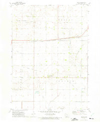 1972 Sexton1975 Print · USGSAgricultural life in Kossuth County during the early seventies centers on the rail-side village of Sexton. Researchers can trace the legacy of rural Iowa through the Old Railroad Grade, the Wesley Evergreen Cem, and the small community of St Benedict.
 - 1972 Map of Wesley, 1975 Print
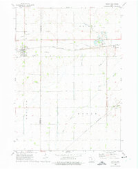 1972 Wesley1975 Print · USGSThe North-Central Iowa prairie is documented here in the early 1970s, showcasing a landscape defined by heavy rail and extensive drainage engineering. Researchers can locate the small communities of Hutchins and Stilson, or trace family roots at St Joseph Cem and Township Cem.
End of results
Showing maps 1-2 of 2
Top cities near Wesley
- Algona historical maps
- Britt historical maps
- Bancroft historical maps
- Kanawha historical maps
- Titonka historical maps
- Burt historical maps
See more
Frequently asked questions
- What are the different types of historical maps available for Wesley?
- What is the oldest map of Wesley?
- Where can I purchase historical maps of Wesley for my home or office?
- Where can I download high-res historical maps of Wesley?
- Are there historical topographic maps available for Wesley?
- Is there historical aerial imagery available for Wesley?
- Where are historical maps of Wesley sourced from?