1960s Maps of Lucas County, Iowa
Explore 3 historic maps of Lucas County from the 1960s. These maps offer a rare glimpse into what life looked like during the 1960s — showing old roads, neighborhoods, homes, and landmarks that have changed or disappeared over time.
Whether you're researching your family's past, planning a metal detecting trip, or studying how Lucas County's landscape evolved across the 1960s, these high-resolution maps are a powerful tool for exploring the history of this region.
- Focus on a specific era: All maps on this page are from the 1960s, giving you a focused view of this time period.
- See what’s changed: Compare century-old streets, trails, and buildings to today's modern landscape using overlays and satellite layers.
- Research with precision: Use these maps for genealogy, historical research, land use analysis, or educational projects.
- View, download, or print: Maps are fully viewable online in high resolution, and can be downloaded or printed for your own records.
Start exploring Lucas County's history through authentic maps from the 1960s. This is your window into the past.
Lucas County, IA maps
(3)- 1965 Map of Le Roy, 1966 Print
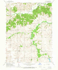 1965 Le Roy1966 Print · USGSSouthern Iowa's rural landscape at the crossroads of four counties is captured here in the mid-1960s. Researchers can trace the path of the Old Railroad Grade or find family sites like Smyrna Cem and the settlement of Last Chance.
 - 1966 Map of Russell, 1967 Print
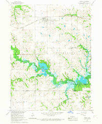 1966 Russell1967 Print · USGSThe Lucas and Wayne County borderlands are seen here in the mid-sixties, just as the landscape was being reshaped by the coming Rathbun Reservoir. Genealogists and historians can trace the rail corridor of the Chicago Burlington and Quincy and locate local sites like Ragtown Cem and Center Community Ch.
 - 1969 Map of Des Moines
 1969 Des Moines1969 Print · USGSCentral Iowa's fertile plains and growing capital are captured here during the late sixties, a time of major highway expansion and reservoir construction. Genealogists and researchers can trace rural township boundaries, local cemeteries, and rail lines serving towns like Pella, Grinnell, and Oskaloosa.
End of results
Showing maps 1-3 of 3
Top cities of Lucas County
- Chariton historical maps
- Russell historical maps
- Lucas historical maps
- Williamson historical maps
- Derby historical maps
Frequently asked questions
- What are the different types of historical maps available for Lucas County?
- What is the oldest map of Lucas County?
- Where can I purchase historical maps of Lucas County for my home or office?
- Where can I download high-res historical maps of Lucas County?
- Are there historical topographic maps available for Lucas County?
- Is there historical aerial imagery available for Lucas County?
- Where are historical maps of Lucas County sourced from?