1980s Maps of Marshall County, Iowa
Explore 8 historic maps of Marshall County from the 1980s. These maps offer a rare glimpse into what life looked like during the 1980s — showing old roads, neighborhoods, homes, and landmarks that have changed or disappeared over time.
Whether you're researching your family's past, planning a metal detecting trip, or studying how Marshall County's landscape evolved across the 1980s, these high-resolution maps are a powerful tool for exploring the history of this region.
- Focus on a specific era: All maps on this page are from the 1980s, giving you a focused view of this time period.
- See what’s changed: Compare century-old streets, trails, and buildings to today's modern landscape using overlays and satellite layers.
- Research with precision: Use these maps for genealogy, historical research, land use analysis, or educational projects.
- View, download, or print: Maps are fully viewable online in high resolution, and can be downloaded or printed for your own records.
Start exploring Marshall County's history through authentic maps from the 1980s. This is your window into the past.
Marshall County, IA maps
(8)- 1980 Map of Newburg
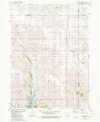 1980 Newburg1980 Print · USGSJasper and Marshall counties are captured in the 1980s as rural agricultural centers defined by the Chicago and North Western railroad. Researchers can trace local heritage through landmarks like Newburg, Hickory Grove Ch, and the recreation areas at Rock Creek State Park.
 - 1980 Map of Gilman
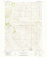 1980 Gilman1980 Print · USGSMid-century Marshall and Tama counties remain centered on their railroad heritage and small township communities. Genealogists and historians can trace the foundations of Gilman, find the rural Stavanger Ch, and locate family plots at Prairie View Cem.
 - 1980 Map of Laurel
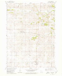 1980 Laurel1980 Print · USGSMarshall County's rural townships are captured in the late twentieth century, showing a landscape of established farmsteads and shifting rail corridors. Genealogists can locate numerous historic burial sites and churches like Center School Cem, Graceland Cem, and the Church of the Bible Covenant.
 - 1980 Map of Alloway Creek
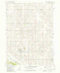 1980 Alloway Creek1980 Print · USGSThe rural borderlands of Jasper and Marshall counties come to life in this 1980 study of the Iowa heartland. Local historians can trace family roots near the Rushville Cem or explore the mid-century development of Mariposa County Park and Ken Wolfe Lake.
 - 1984 Map of Marshalltown, 1985 Print
 1984 Marshalltown1985 Print · USGSMid-Iowa's agricultural landscape and river corridors come alive in the mid-eighties as the Cedar River connects industrial hubs and small farm towns. Trace the tracks of the CHICAGO AND NORTHWESTERN or locate local landmarks like Union Grove State Park and Cedar Falls Junction.2 unique versions available
 - 1984 Map of Des Moines, 1985 Print
 1984 Des Moines1985 Print · USGSCentral Iowa's heartland is captured in the mid-1980s as suburban growth met long-standing farm and rail infrastructure. Genealogists and researchers can trace the reaches of the Chicago and North Western through Maxwell or locate Laurel Hill Cem and Camp Dodge Military Reservation.2 unique versions available
 - 1984 Map of Grinnell, 1985 Print
 1984 Grinnell1985 Print · USGSCentral Iowa's prairie towns and rail corridors are captured in the mid-1980s, showcasing the agricultural grid and protected marshlands. Researchers can trace historic routes along the Chicago and North Western or locate family roots near the Sac and Fox Indian Reservation and Lake Ponderosa.2 unique versions available
 - 1985 Map of Ames
 1985 Ames1985 Print · USGSCentral Iowa's prairie landscape in the mid-eighties shows a well-established network of rail towns and conservation areas. Genealogists and historians can trace the paths of the Lincoln Highway and the Chicago and North Western line connecting Ames, Boone, and Webster City.
End of results
Showing maps 1-8 of 8
Top cities of Marshall County
Frequently asked questions
- What are the different types of historical maps available for Marshall County?
- What is the oldest map of Marshall County?
- Where can I purchase historical maps of Marshall County for my home or office?
- Where can I download high-res historical maps of Marshall County?
- Are there historical topographic maps available for Marshall County?
- Is there historical aerial imagery available for Marshall County?
- Where are historical maps of Marshall County sourced from?