1970s Maps of St. Anthony, Iowa
Explore 2 historic maps of St. Anthony from the 1970s. These maps offer a rare glimpse into what life looked like during the 1970s — showing old roads, neighborhoods, homes, and landmarks that have changed or disappeared over time.
Whether you're researching your family's past, planning a metal detecting trip, or studying how St. Anthony's landscape evolved across the 1970s, these high-resolution maps are a powerful tool for exploring the history of this region.
- Focus on a specific era: All maps on this page are from the 1970s, giving you a focused view of this time period.
- See what’s changed: Compare century-old streets, trails, and buildings to today's modern landscape using overlays and satellite layers.
- Research with precision: Use these maps for genealogy, historical research, land use analysis, or educational projects.
- View, download, or print: Maps are fully viewable online in high resolution, and can be downloaded or printed for your own records.
Start exploring St. Anthony's history through authentic maps from the 1970s. This is your window into the past.
St. Anthony, IA maps
(2)- 1975 Map of State Center NW, 1978 Print
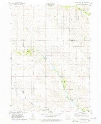 1975 State Center NW1978 Print · USGSMarshall County farmsteads and creek valleys are documented here in the mid-seventies, showing the rural landscape before further consolidation. Researchers can locate St Anthony, several Gravel Pits, and local landmarks like Illinois Grove Cem.
 - 1975 Map of State Center, 1978 Print
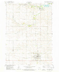 1975 State Center1978 Print · USGSCentral Marshall County thrived in the mid-seventies as a hub of rail activity and rural settlement. Researchers can trace the Chicago and Northwestern line or locate family sites like Sacred Heart Cem and St Johns Ch.
End of results
Showing maps 1-2 of 2
Top cities near St. Anthony
- Eldora historical maps
- State Center historical maps
- Hubbard historical maps
- Maxwell historical maps
- Colo historical maps
- Melbourne historical maps
See more
Top neighborhoods of St. Anthony
Frequently asked questions
- What are the different types of historical maps available for St. Anthony?
- What is the oldest map of St. Anthony?
- Where can I purchase historical maps of St. Anthony for my home or office?
- Where can I download high-res historical maps of St. Anthony?
- Are there historical topographic maps available for St. Anthony?
- Is there historical aerial imagery available for St. Anthony?
- Where are historical maps of St. Anthony sourced from?