1970s Maps of Polk County, Iowa
Explore 8 historic maps of Polk County from the 1970s. These maps offer a rare glimpse into what life looked like during the 1970s — showing old roads, neighborhoods, homes, and landmarks that have changed or disappeared over time.
Whether you're researching your family's past, planning a metal detecting trip, or studying how Polk County's landscape evolved across the 1970s, these high-resolution maps are a powerful tool for exploring the history of this region.
- Focus on a specific era: All maps on this page are from the 1970s, giving you a focused view of this time period.
- See what’s changed: Compare century-old streets, trails, and buildings to today's modern landscape using overlays and satellite layers.
- Research with precision: Use these maps for genealogy, historical research, land use analysis, or educational projects.
- View, download, or print: Maps are fully viewable online in high resolution, and can be downloaded or printed for your own records.
Start exploring Polk County's history through authentic maps from the 1970s. This is your window into the past.
Polk County, IA maps
(8)- 1972 Map of Runnells, 1974 Print
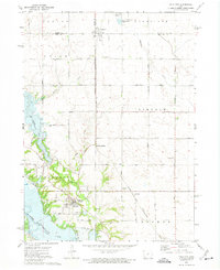
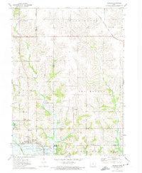 1972 Runnells1974 Print · USGSRunnells and the southern Polk County borderlands are shown here in the early seventies, just as the regional landscape was adjusting to the presence of Lake Red Rock. Researchers can trace old family sites and rural infrastructure through the Vandalia Cem, the Runnells Sch, and the Norfolk and Western rail line.
 - 1972 Map of Altoona, 1974 Print
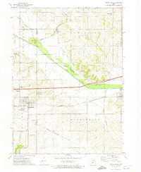
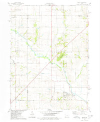
 1972 Altoona1974 Print · USGSPolk County enters a decade of modern growth and infrastructure expansion in the early seventies. Genealogists and local researchers can trace the rail lines of the Chicago and North Western or locate family plots at Altoona Cem and Franklin Cem.2 unique versions available
 - 1972 Map of Rising Sun, 1974 Print
 1972 Rising Sun1974 Print · USGSSoutheast of Des Moines in the early seventies, the river landscape around Carlisle and Rising Sun shows a blend of rural township life and growing suburban tracts. Researchers can trace the heritage of local families at Powers-Warren Cem and locate old rail corridors like the Chicago Rock Island and Pacific Railroad.
 - 1972 Map of Mitchellville, 1974 Print
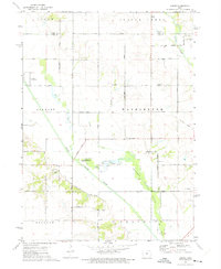
 1972 Mitchellville1974 Print · USGSAcross the Polk and Jasper County line in the early 1970s, this area shows a landscape defined by rail corridors and the meandering South Skunk River. Genealogists can locate family landmarks like Sams Cem and Fisher Cem or trace the small-town footprints of Valeria and Mitchellville.
 - 1972 Map of Elkhart, 1975 Print
 1972 Elkhart1975 Print · USGSNorth of Des Moines in the early seventies, this rural landscape reveals the tightly organized farm grids and rail towns of Polk County. Genealogists can locate family landmarks like Keller Cem, White Oak Ch, and the streets of Alleman.
 - 1972 Map of Loring, 1975 Print
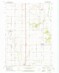
 1972 Loring1975 Print · USGSAgricultural life in central Iowa during the early 1970s centers on the South Skunk River and the small hamlet of Loring. Researchers can trace local history through sites like the Brethren Cem, Holy Cross Ch, and an Old Railroad Grade.
 - 1972 Map of Polk City, 1975 Print
 1972 Polk City1975 Print · USGSCentral Iowa was undergoing a massive landscape shift in the early seventies as the Saylorville project took shape. Researchers can trace the original rail path of the Chicago and North Western and locate quiet rural landmarks like Sheldahl Cem and Crocker.2 unique versions available
 - 1975 Map of Mingo, 1978 Print
 1975 Mingo1978 Print · USGSMid-Iowa's agricultural landscape comes into focus during the 1970s at the junction of Story, Jasper, and Polk counties. Researchers can trace rural genealogy and transport through Mingo, the Old RR Grade at Farrar, and local landmarks like Ashton Ch and Deeter Cem.
End of results
Showing maps 1-8 of 8
Top cities of Polk County
- Des Moines historical maps
- Ankeny historical maps
- Johnston historical maps
- Altoona historical maps
- Pleasant Hill historical maps
- Bondurant historical maps
See more
Frequently asked questions
- What are the different types of historical maps available for Polk County?
- What is the oldest map of Polk County?
- Where can I purchase historical maps of Polk County for my home or office?
- Where can I download high-res historical maps of Polk County?
- Are there historical topographic maps available for Polk County?
- Is there historical aerial imagery available for Polk County?
- Where are historical maps of Polk County sourced from?