1950s Maps of Cleona Township, Iowa
Explore 5 historic maps of Cleona Township from the 1950s. These maps offer a rare glimpse into what life looked like during the 1950s — showing old roads, neighborhoods, homes, and landmarks that have changed or disappeared over time.
Whether you're researching your family's past, planning a metal detecting trip, or studying how Cleona Township's landscape evolved across the 1950s, these high-resolution maps are a powerful tool for exploring the history of this region.
- Focus on a specific era: All maps on this page are from the 1950s, giving you a focused view of this time period.
- See what’s changed: Compare century-old streets, trails, and buildings to today's modern landscape using overlays and satellite layers.
- Research with precision: Use these maps for genealogy, historical research, land use analysis, or educational projects.
- View, download, or print: Maps are fully viewable online in high resolution, and can be downloaded or printed for your own records.
Start exploring Cleona Township's history through authentic maps from the 1950s. This is your window into the past.
Cleona Township, IA maps
(5)- 1953 Map of Bennett, 1958 Print
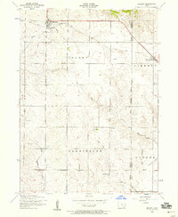 1953 Bennett1958 Print · USGSEastern Iowa farm country is captured here in the early fifties, showing the transition from rail-dependent commerce to a modern road network. Genealogists can locate several rural schoolhouses like Sunbury School and Center School, plus the Grain Elevator in Bennett.2 unique versions available
 - 1953 Map of Walcott, 1958 Print
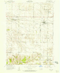 1953 Walcott1958 Print · USGSThe rural landscape of Scott and Muscatine counties thrived in the early 1950s around a busy network of country schools and the Rock Island railroad. Researchers can trace family ties at Parr Cemetery, Stockton Consolidated School, and the community of Blue Grass.2 unique versions available
 - 1953 Map of Dixon, 1958 Print
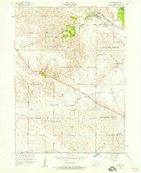 1953 Dixon1958 Print · USGSDixon and the surrounding Scott County townships are seen here in the early fifties, caught at the intersection of the Wapsipinicon River and the rail line. Researchers can trace rural landmarks from Plain View to the Conestoga Girl Scout Camp and several local schoolhouses.3 unique versions available
 - 1953 Map of Durant, 1958 Print
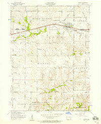 1953 Durant1958 Print · USGSEastern Iowa farmland at the start of the fifties is captured here, centered on the tri-county junction of Cedar, Muscatine, and Scott. Genealogists can trace rural life through a dense network of country schools like Yankee Hollow School and old burial grounds such as Melpine Cemetery.2 unique versions available
 - 1958 Map of Davenport, 1968 Print
 1958 Davenport1968 Print · USGSEastern Iowa and western Illinois thrive along the river during the late fifties, defined by the industrial Quad Cities and a robust rail network. Genealogists can trace family roots through settlements like Oasis and Stanwood or along the Cedar River.2 unique versions available
End of results
Showing maps 1-5 of 5
Top cities near Cleona Township
- Davenport historical maps
- Rock Island historical maps
- Muscatine historical maps
- Eldridge historical maps
- Wilton historical maps
- Durant historical maps
See more
Frequently asked questions
- What are the different types of historical maps available for Cleona Township?
- What is the oldest map of Cleona Township?
- Where can I purchase historical maps of Cleona Township for my home or office?
- Where can I download high-res historical maps of Cleona Township?
- Are there historical topographic maps available for Cleona Township?
- Is there historical aerial imagery available for Cleona Township?
- Where are historical maps of Cleona Township sourced from?