1950s Maps of Davenport, Iowa
Explore 8 historic maps of Davenport from the 1950s. These maps offer a rare glimpse into what life looked like during the 1950s — showing old roads, neighborhoods, homes, and landmarks that have changed or disappeared over time.
Whether you're researching your family's past, planning a metal detecting trip, or studying how Davenport's landscape evolved across the 1950s, these high-resolution maps are a powerful tool for exploring the history of this region.
- Focus on a specific era: All maps on this page are from the 1950s, giving you a focused view of this time period.
- See what’s changed: Compare century-old streets, trails, and buildings to today's modern landscape using overlays and satellite layers.
- Research with precision: Use these maps for genealogy, historical research, land use analysis, or educational projects.
- View, download, or print: Maps are fully viewable online in high resolution, and can be downloaded or printed for your own records.
Start exploring Davenport's history through authentic maps from the 1950s. This is your window into the past.
Davenport, IA maps
(8)- 1950 Map of Milan
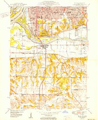 1950 Milan1950 Print · USGSThe Tri-Cities area comes alive in the mid-century as industrial centers like Rock Island and Moline expand across the river islands. Researchers can locate dozens of local landmarks, from Chippiannock Cem to rural outposts like Tindall School No 1.2 unique versions available
 - 1953 Map of Silvis, 1956 Print
 1953 Silvis1956 Print · USGSThe Quad Cities area flourished in the early fifties as an industrial powerhouse along the Mississippi River. Genealogists and historians can trace the footprint of the East Moline State Hospital, several rural schools like Barr School, and the grounds of Fairview Cemetery.3 unique versions available
 - 1953 Map of Davenport East, 1956 Print
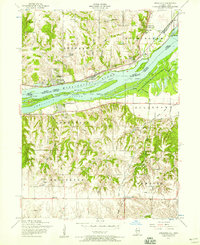
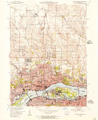 1953 Davenport East1956 Print · USGSThe Quad Cities are captured at a peak of mid-century growth, following the path of the Mississippi River and the bustling Rock Island Arsenal. Local historians can trace family roots at St Ambrose College or locate the former aviation hub at Cram Field.3 unique versions available
 - 1953 Map of Milan, 1956 Print
 1953 Milan1956 Print · USGSThe Quad Cities area in the early fifties shows a landscape of river-driven industry and rapid post-war growth. Genealogists can trace family roots through numerous named schools and cemeteries like Chippiannock Cemetery and the rural Pleasant Hill Cem.3 unique versions available
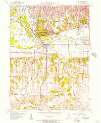
 - 1953 Map of Davenport West, 1958 Print
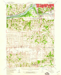
 1953 Davenport West1958 Print · USGSThe western edges of Davenport and the surrounding Scott County townships are captured here in the early fifties. Genealogists and local historians can trace rural school districts from Fairview School to School No. 5 and locate family burial sites like Friday Family Cemetery.3 unique versions available
 - 1953 Map of Andalusia, 1958 Print
 1953 Andalusia1958 Print · USGSThe Mississippi River corridor south of Davenport is captured here in the early fifties, showing a landscape defined by rail lines and river islands. Researchers can locate rural landmarks like Asbury Cemetery, Buffalo Heights, and the Coon Hunters Club along the bluffs.3 unique versions available
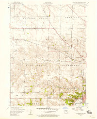
 - 1953 Map of Milan, 1959 Print
 1953 Milan1959 Print · USGSRock Island County and the Mississippi riverfront are captured here in the mid-fifties, showing the region's transition from river-town industry to suburban growth. Genealogists and historians can locate numerous rural landmarks like St Josephs Ch, Colony Cem, and the old Edgington Sch.
 - 1958 Map of Davenport, 1968 Print
 1958 Davenport1968 Print · USGSEastern Iowa and western Illinois thrive along the river during the late fifties, defined by the industrial Quad Cities and a robust rail network. Genealogists can trace family roots through settlements like Oasis and Stanwood or along the Cedar River.2 unique versions available
End of results
Showing maps 1-8 of 8
Top cities near Davenport
- Moline historical maps
- Bettendorf historical maps
- Rock Island historical maps
- East Moline historical maps
- Silvis historical maps
- Eldridge historical maps
See more
Top neighborhoods of Davenport
- Walnut Grove historical maps
- Nahant historical maps
- Village of East Davenport historical maps
- Park Lawn historical maps
- Americana Park historical maps
- Riverview Terrace Historic District historical maps
See more
Frequently asked questions
- What are the different types of historical maps available for Davenport?
- What is the oldest map of Davenport?
- Where can I purchase historical maps of Davenport for my home or office?
- Where can I download high-res historical maps of Davenport?
- Are there historical topographic maps available for Davenport?
- Is there historical aerial imagery available for Davenport?
- Where are historical maps of Davenport sourced from?