1990s Maps of Davenport, Iowa
Explore 6 historic maps of Davenport from the 1990s. These maps offer a rare glimpse into what life looked like during the 1990s — showing old roads, neighborhoods, homes, and landmarks that have changed or disappeared over time.
Whether you're researching your family's past, planning a metal detecting trip, or studying how Davenport's landscape evolved across the 1990s, these high-resolution maps are a powerful tool for exploring the history of this region.
- Focus on a specific era: All maps on this page are from the 1990s, giving you a focused view of this time period.
- See what’s changed: Compare century-old streets, trails, and buildings to today's modern landscape using overlays and satellite layers.
- Research with precision: Use these maps for genealogy, historical research, land use analysis, or educational projects.
- View, download, or print: Maps are fully viewable online in high resolution, and can be downloaded or printed for your own records.
Start exploring Davenport's history through authentic maps from the 1990s. This is your window into the past.
Davenport, IA maps
(6)- 1991 Map of Davenport West, 1992 Print
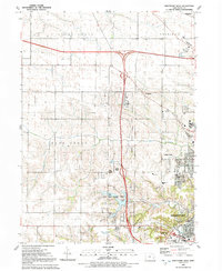 1991 Davenport West1992 Print · USGSDavenport's western periphery in the early nineties shows a landscape of suburban growth meeting traditional Iowa farm townships. Genealogists and local historians can trace family burial sites like Kisenmacher Cem and Friday Family Cem or find established institutions like West High Sch.
 - 1991 Map of Silvis, 1992 Print
 1991 Silvis1992 Print · USGSThe riverfront communities of the Quad Cities thrive along both banks of the Mississippi in the early nineties. Genealogists and local historians can locate family landmarks like Fairview Cem, Forest Grove Sch, and the Quad City Downs racetrack.
 - 1991 Map of Andalusia, 1992 Print
 1991 Andalusia1992 Print · USGSThe Mississippi River valley comes into focus during the early nineties, showing the industrial and residential growth of the Quad Cities periphery. Trace the evolution of transport and burials via the Old RR GB, Asbury Cem, and the riverside town of Andalusia.
 - 1991 Map of Davenport East, 1992 Print
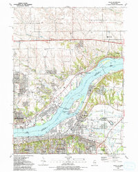
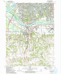
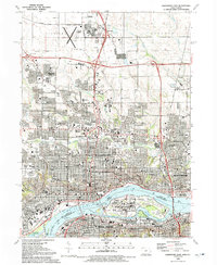 1991 Davenport East1992 Print · USGSThe Quad Cities region thrives along the river in the early nineties, showing the dense urban centers of Davenport and Rock Island. Researchers can trace the massive Rock Island Arsenal, historical burial sites like Confederate Cem, and local institutions like Augustana College.
 - 1992 Map of Milan
 1992 Milan1992 Print · USGSThe Quad Cities area at the start of the 1990s showcases the meeting of the Mississippi and Rock Rivers amidst a landscape of established urban centers and riverine islands. Genealogists and local researchers can trace numerous family sites at Chippiannock Cem or locate community landmarks like Wharton Field House and Camden Park.
 - 1993 Map of Davenport East, 1999 Print
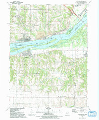
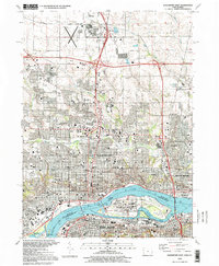 1993 Davenport East1999 Print · USGSThe Quad Cities are captured here in the 1990s, showcasing the complex urban and industrial landscape where the Iowa and Illinois borders meet. Genealogists and local historians can trace legacy sites like Oakdale Cemetery, the Rock Island Arsenal, and institutions such as Palmer College of Chiropractic.
End of results
Showing maps 1-6 of 6
Top cities near Davenport
- Moline historical maps
- Bettendorf historical maps
- Rock Island historical maps
- East Moline historical maps
- Silvis historical maps
- Eldridge historical maps
See more
Top neighborhoods of Davenport
- Walnut Grove historical maps
- Nahant historical maps
- Village of East Davenport historical maps
- Park Lawn historical maps
- Americana Park historical maps
- Riverview Terrace Historic District historical maps
See more
Frequently asked questions
- What are the different types of historical maps available for Davenport?
- What is the oldest map of Davenport?
- Where can I purchase historical maps of Davenport for my home or office?
- Where can I download high-res historical maps of Davenport?
- Are there historical topographic maps available for Davenport?
- Is there historical aerial imagery available for Davenport?
- Where are historical maps of Davenport sourced from?