1991 Map of Davenport West
USGS Topo · Published 1992About this map
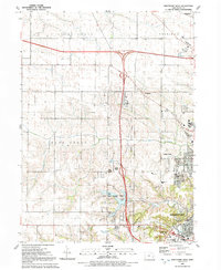
The Davenport Corporate Boundary marks the transition from urban expansion to the agricultural townships of Blue Grass, Hickory Grove, and Sheridan. In the early 1990s, this area reflects the growing suburban and industrial footprint west of the city center, characterized by the major highway junctions of Interstate 80 and Interstate 280. Local heritage is preserved at the Kisenmacher Cem and Friday Family Cem, while the landscape is punctuated by the expansive West Lake County Park and the Emeis Park golf course. Notable institutional landmarks include the West High Sch and the Royal Neighbors of America Home near the southern edge of the quadrangle. Small settlements like Probstei and Little Groves sit alongside the winding paths of Duck Creek and Black Hawk Creek, illustrating the balance between modern infrastructure and Iowa's traditional creek-side terrain.
Find a feature on this map
35 named features on this map. Tap any name to fly to it.
Don’t see what you’re looking for? This feature index may not catch every label — zoom into the map to look around manually.
Map Details
Editions of this 1991 Davenport West Map
This is the sole edition of this map. No revisions or reprints were ever made.
Other maps of this area

1890 · Durant
USGS Topo · 1:62,500

1891 · Davenport
USGS Topo · 1:62,500

1894 · Durant
USGS Topo · 1:62,500

1894 · Davenport
USGS Topo · 1:62,500

1901 · Rock Island
USGS Topo · 1:125,000

1910 · Rock Island
USGS Topo · 1:125,000

1912 · Milan
USGS Topo · 1:62,500

1916 · Edgington
USGS Topo · 1:62,500

1938 · Edgington
USGS Topo · 1:62,500

1944 · Milan
USGS Topo · 1:62,500