
1910 Map of Rock Island
USGS Topo · Published 1949About this map
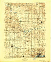
The Wapsipinicon River winds through this late 19th-century landscape, carving a path across the state line and through a network of fledgling prairie towns. Surveyed by W. J. Peters and Nat Tyler, Jr. between 1889 and 1898, the map reveals a region defined by its competing rail corridors. Major lines like the Chicago Milwaukee and St. Paul R.R. and the Chicago and Northwestern R.R. dictate the placement of settlements such as Oxford Junction, Lost Nation, and Dewitt. At the southern edge, the industrial and military importance of the river becomes clear at the U.S. Arsenal, situated on an island in the Mississippi. Small farming communities and townships like Allen's Grove and Winfield are documented here in their early stages of development, prior to the large-scale consolidation of the 20th century.
Find a feature on this map
92 named features on this map. Tap any name to fly to it.
Don’t see what you’re looking for? This feature index may not catch every label — zoom into the map to look around manually.
Map Details
Editions of this 1910 Rock Island Map
This is the sole edition of this map. No revisions or reprints were ever made.
Historical Maps of Davenport Through Time
Featured Locations
- Moline, IL
- Rock Island, IL
- Davenport, IA
- Bettendorf, Pleasant Valley Township
- Eldridge, Sheridan Township