1990s Maps of Le Claire Township, Iowa
Explore 4 historic maps of Le Claire Township from the 1990s. These maps offer a rare glimpse into what life looked like during the 1990s — showing old roads, neighborhoods, homes, and landmarks that have changed or disappeared over time.
Whether you're researching your family's past, planning a metal detecting trip, or studying how Le Claire Township's landscape evolved across the 1990s, these high-resolution maps are a powerful tool for exploring the history of this region.
- Focus on a specific era: All maps on this page are from the 1990s, giving you a focused view of this time period.
- See what’s changed: Compare century-old streets, trails, and buildings to today's modern landscape using overlays and satellite layers.
- Research with precision: Use these maps for genealogy, historical research, land use analysis, or educational projects.
- View, download, or print: Maps are fully viewable online in high resolution, and can be downloaded or printed for your own records.
Start exploring Le Claire Township's history through authentic maps from the 1990s. This is your window into the past.
Le Claire Township, IA maps
(4)- 1991 Map of Silvis, 1992 Print
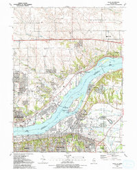 1991 Silvis1992 Print · USGSThe riverfront communities of the Quad Cities thrive along both banks of the Mississippi in the early nineties. Genealogists and local historians can locate family landmarks like Fairview Cem, Forest Grove Sch, and the Quad City Downs racetrack.
 - 1991 Map of Mc Causland, 1992 Print
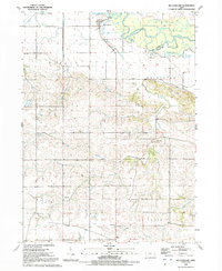 1991 Mc Causland1992 Print · USGSThe rural borderlands of Scott and Clinton counties come into focus in the early nineties, centered on the Wapsipinicon River valley. Genealogists and local historians can trace rural settlements like McCausland and Argo, as well as landmarks like Fessler Cem and the historic Territorial Road.
 - 1991 Map of Cordova, 1992 Print
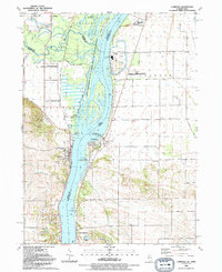 1991 Cordova1992 Print · USGSThe riverfront communities of Rock Island and Scott counties are captured here in the late twentieth century as industry and recreation converge. Researchers can trace local heritage through sites like Virgil Grissom Sch, Our Lady of the River Ch, and Jacks Cem.
 - 1991 Map of Port Byron, 1992 Print
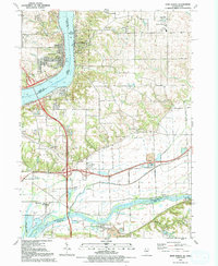 1991 Port Byron1992 Print · USGSThe riverfront communities of Port Byron and Le Claire are captured here in the early nineties as they expanded along the Mississippi. Genealogists and historians can trace numerous family landmarks like Yost Cem, Edwards Cem, and the Cody Sch.
End of results
Showing maps 1-4 of 4
Top cities near Le Claire Township
- Davenport historical maps
- Moline historical maps
- Bettendorf historical maps
- Rock Island historical maps
- Clinton historical maps
- East Moline historical maps
See more
Top neighborhoods of Le Claire Township
Frequently asked questions
- What are the different types of historical maps available for Le Claire Township?
- What is the oldest map of Le Claire Township?
- Where can I purchase historical maps of Le Claire Township for my home or office?
- Where can I download high-res historical maps of Le Claire Township?
- Are there historical topographic maps available for Le Claire Township?
- Is there historical aerial imagery available for Le Claire Township?
- Where are historical maps of Le Claire Township sourced from?