1950s Maps of Le Claire Township, Iowa
Explore 7 historic maps of Le Claire Township from the 1950s. These maps offer a rare glimpse into what life looked like during the 1950s — showing old roads, neighborhoods, homes, and landmarks that have changed or disappeared over time.
Whether you're researching your family's past, planning a metal detecting trip, or studying how Le Claire Township's landscape evolved across the 1950s, these high-resolution maps are a powerful tool for exploring the history of this region.
- Focus on a specific era: All maps on this page are from the 1950s, giving you a focused view of this time period.
- See what’s changed: Compare century-old streets, trails, and buildings to today's modern landscape using overlays and satellite layers.
- Research with precision: Use these maps for genealogy, historical research, land use analysis, or educational projects.
- View, download, or print: Maps are fully viewable online in high resolution, and can be downloaded or printed for your own records.
Start exploring Le Claire Township's history through authentic maps from the 1950s. This is your window into the past.
Le Claire Township, IA maps
(7)- 1950 Map of Port Byron
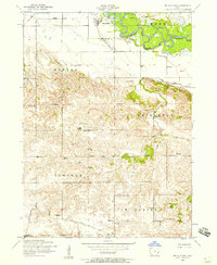
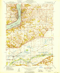 1950 Port Byron1950 Print · USGSThe Illinois-Iowa border along the Mississippi River thrives as a rail and river hub at the middle of the twentieth century. Local historians can trace family roots through numerous rural landmarks like Shake-Rag Sch, St Johns Cem, and Rapids City.
 - 1952 Map of Cordova, 1953 Print
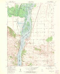
 1952 Cordova1953 Print · USGSRock Island County shoreline life is captured here in the early fifties, following the river as it winds past developing river towns. Genealogists can locate family landmarks like Williams Sch, Fairfield Ch, and the Baker Cem.
 - 1953 Map of Silvis, 1956 Print
 1953 Silvis1956 Print · USGSThe Quad Cities area flourished in the early fifties as an industrial powerhouse along the Mississippi River. Genealogists and historians can trace the footprint of the East Moline State Hospital, several rural schools like Barr School, and the grounds of Fairview Cemetery.3 unique versions available
 - 1953 Map of Port Byron, 1957 Print
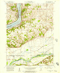 1953 Port Byron1957 Print · USGSThe Mississippi and Rock Rivers converge in the 1950s, defining a landscape of active rail lines and riverfront towns. Researchers can trace historic family burial sites and rural schoolhouses like Yost Cemetery, Friedens Church, and Sycamore School.3 unique versions available
 - 1953 Map of Cordova, 1957 Print
 1953 Cordova1957 Print · USGSThe Mississippi River forms the heart of this mid-century borderland between Illinois and Iowa, where riverfront towns like Cordova and Princeton thrived. Researchers can pinpoint family-named landmarks such as Nowlin Cemetery, Scharff School, and Camp Hauberg.3 unique versions available
 - 1953 Map of Mc Causland, 1957 Print
 1953 Mc Causland1957 Print · USGSIn the mid-1950s, the rural border between Scott and Clinton counties remained a landscape of small schools and country churches. Genealogists can trace family roots at Fessler Cemetery or Mt Union Church and locate several country schoolhouses like Argo School.3 unique versions available
 - 1958 Map of Davenport, 1968 Print
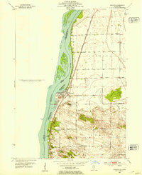
 1958 Davenport1968 Print · USGSEastern Iowa and western Illinois thrive along the river during the late fifties, defined by the industrial Quad Cities and a robust rail network. Genealogists can trace family roots through settlements like Oasis and Stanwood or along the Cedar River.2 unique versions available
End of results
Showing maps 1-7 of 7
Top cities near Le Claire Township
- Davenport historical maps
- Moline historical maps
- Bettendorf historical maps
- Rock Island historical maps
- Clinton historical maps
- East Moline historical maps
See more
Top neighborhoods of Le Claire Township
Frequently asked questions
- What are the different types of historical maps available for Le Claire Township?
- What is the oldest map of Le Claire Township?
- Where can I purchase historical maps of Le Claire Township for my home or office?
- Where can I download high-res historical maps of Le Claire Township?
- Are there historical topographic maps available for Le Claire Township?
- Is there historical aerial imagery available for Le Claire Township?
- Where are historical maps of Le Claire Township sourced from?