
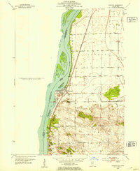
1950 Map of Port Byron
USGS Topo · Published 1950About this map
Port Byron sits at a critical bend where the Mississippi River creates a natural bottleneck, shaping the development of the riverfront towns of Le Claire and Rapids City during the mid-century. The landscape is defined by the dual influence of the Mississippi and the Rock River, which meet south of Barstow. This 1950 survey reveals a dense network of country education and faith, including uniquely named landmarks like Shake-Rag Sch and Leafy Bower Sch.
Find a feature on this map
47 named features on this map. Tap any name to fly to it.
Don’t see what you’re looking for? This feature index may not catch every label — zoom into the map to look around manually.
Map Details
Editions of this 1950 Port Byron Map
This is the sole edition of this map. No revisions or reprints were ever made.
Other maps of this area

1892 · Leclaire
USGS Topo · 1:62,500

1893 · Leclaire
USGS Topo · 1:62,500

1899 · Clinton
USGS Topo · 1:125,000

1934 · Geneseo
USGS Topo · 1:62,500

1937 · Orion
USGS Topo · 1:62,500

1949 · Coal Valley
USGS Topo · 1:24,000

1949 · Silvis
USGS Topo · 1:24,000

1949 · Port Byron
USGS Topo · 1:24,000

1952 · Erie
USGS Topo · 1:62,500
1952 · Cordova
USGS Topo · 1:24,000