1960s Maps of Alton, Iowa
Explore 4 historic maps of Alton from the 1960s. These maps offer a rare glimpse into what life looked like during the 1960s — showing old roads, neighborhoods, homes, and landmarks that have changed or disappeared over time.
Whether you're researching your family's past, planning a metal detecting trip, or studying how Alton's landscape evolved across the 1960s, these high-resolution maps are a powerful tool for exploring the history of this region.
- Focus on a specific era: All maps on this page are from the 1960s, giving you a focused view of this time period.
- See what’s changed: Compare century-old streets, trails, and buildings to today's modern landscape using overlays and satellite layers.
- Research with precision: Use these maps for genealogy, historical research, land use analysis, or educational projects.
- View, download, or print: Maps are fully viewable online in high resolution, and can be downloaded or printed for your own records.
Start exploring Alton's history through authentic maps from the 1960s. This is your window into the past.
Alton, IA maps
(4)- 1962 Map of Le Mars, 1964 Print
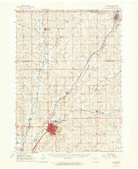 1962 Le Mars1964 Print · USGSNorthwestern Iowa's agricultural heartland is documented here in the early sixties, centered on the growing community of Le Mars. Researchers can trace old rail corridors like the ILLINOIS CENTRAL, locate family plots at Resthaven Cemetery, or find historical landmarks like Westmar College.
 - 1964 Map of Hospers, 1965 Print
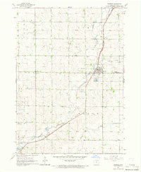 1964 Hospers1965 Print · USGSNorthwest Iowa’s agricultural heartland is documented here in the mid-1960s, showing the intersection of rail and river commerce. Genealogists and historians can trace the town sites of Hospers and Newkirk, or locate ancestors at St Anthonys Cem.
 - 1964 Map of Orange City, 1965 Print
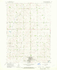 1964 Orange City1965 Print · USGSSioux County's agricultural heartland is captured in the mid-1960s, centered on the growing town of Orange City. Genealogists and researchers can trace local landmarks like the County Home, Middleburg Cem, and the small settlement of Middleburg.
 - 1969 Map of Granville West, 1971 Print
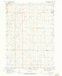 1969 Granville West1971 Print · USGSNorthwest Iowa's agricultural landscape is captured here in the late sixties as the township system matured. Researchers can trace the path of the Chicago and North Western railroad near Granville or follow the banks of Willow Creek and Deep Creek.
End of results
Showing maps 1-4 of 4
Top cities near Alton
- Le Mars historical maps
- Sioux Center historical maps
- Orange City historical maps
- Sheldon historical maps
- Hull historical maps
- Remsen historical maps
See more
Frequently asked questions
- What are the different types of historical maps available for Alton?
- What is the oldest map of Alton?
- Where can I purchase historical maps of Alton for my home or office?
- Where can I download high-res historical maps of Alton?
- Are there historical topographic maps available for Alton?
- Is there historical aerial imagery available for Alton?
- Where are historical maps of Alton sourced from?