1980s Maps of Van Buren County, Iowa
Explore 8 historic maps of Van Buren County from the 1980s. These maps offer a rare glimpse into what life looked like during the 1980s — showing old roads, neighborhoods, homes, and landmarks that have changed or disappeared over time.
Whether you're researching your family's past, planning a metal detecting trip, or studying how Van Buren County's landscape evolved across the 1980s, these high-resolution maps are a powerful tool for exploring the history of this region.
- Focus on a specific era: All maps on this page are from the 1980s, giving you a focused view of this time period.
- See what’s changed: Compare century-old streets, trails, and buildings to today's modern landscape using overlays and satellite layers.
- Research with precision: Use these maps for genealogy, historical research, land use analysis, or educational projects.
- View, download, or print: Maps are fully viewable online in high resolution, and can be downloaded or printed for your own records.
Start exploring Van Buren County's history through authentic maps from the 1980s. This is your window into the past.
Van Buren County, IA maps
(8)- 1980 Map of Fairfield South, 1981 Print
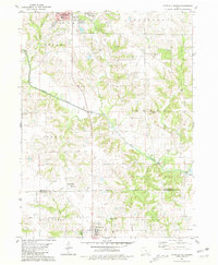 1980 Fairfield South1981 Print · USGSThe Jefferson and Van Buren county line comes to life in the late seventies as rural farmland meets the expanding edges of Fairfield. Genealogists can trace family names at Roth Cem and Smith Cem or locate community landmarks like the County Home.
 - 1980 Map of Lockridge West, 1981 Print
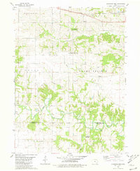 1980 Lockridge West1981 Print · USGSJefferson and Van Buren counties appear in the early eighties as a network of rural townships and winding creek bottoms. Researchers can locate numerous family burial sites like Bonnifield Cem or trace the Burlington Northern line near Lockridge.
 - 1980 Map of Lockridge East, 1981 Print
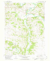 1980 Lockridge East1981 Print · USGSThe Skunk River and Cedar Creek basins in the early 1980s show a well-defined landscape of rail-connected towns and rural parishes. Genealogists and historians can locate community landmarks like Grant Cem, the Burlington Northern line, and Round Prairie Ch.
 - 1981 Map of Mount Zion
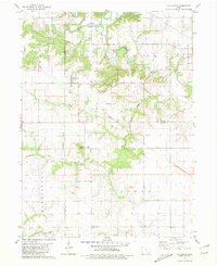
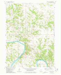 1981 Mount Zion1981 Print · USGSVan Buren County's river-cut landscape is captured here in the early eighties as the Chicago Rock Island and Pacific railroad still traced the Des Moines River. Genealogists can locate several family-named landmarks including Forbes Cem, Leech Cem, and the community at Winchester.
 - 1981 Map of Hillsboro
 1981 Hillsboro1981 Print · USGSSoutheast Iowa in the early eighties shows a transition from traditional rail-connected towns to modern rural management. Trace the path of the Old Railroad Grade past Hillsboro and locate family burial sites at Bayles Cem and the local Cemetery.
 - 1981 Map of Stockport
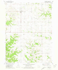 1981 Stockport1981 Print · USGSVan Buren County agriculture and early industrial remnants are documented here in the early 1980s. Researchers can trace the Old Railroad Grade through McVeigh or locate rural landmarks like Big Cedar Ch and Dibble Cem.
 - 1981 Map of Centerville, 1982 Print
 1981 Centerville1982 Print · USGSThe borderlands of southern Iowa and northern Missouri are captured here in the early eighties as Rathbun Lake and the Chariton River define the local geography. Researchers can trace historic rail lines like the Norfolk and Western and locate vanished hamlets such as Coal City and Glenwood Junction.
 - 1985 Map of Burlington
 1985 Burlington1985 Print · USGSThe Tri-State region during the mid-eighties shows a landscape shaped by the Mississippi River and a dense network of railroads. Genealogists and local historians can trace family sites near Aspen Grove Cem or locate community landmarks in Burlington, Fort Madison, and Mount Pleasant.2 unique versions available
End of results
Showing maps 1-8 of 8
Top cities of Van Buren County
- Keosauqua historical maps
- Farmington historical maps
- Milton historical maps
- Birmingham historical maps
- Bonaparte historical maps
- Stockport historical maps
See more
Frequently asked questions
- What are the different types of historical maps available for Van Buren County?
- What is the oldest map of Van Buren County?
- Where can I purchase historical maps of Van Buren County for my home or office?
- Where can I download high-res historical maps of Van Buren County?
- Are there historical topographic maps available for Van Buren County?
- Is there historical aerial imagery available for Van Buren County?
- Where are historical maps of Van Buren County sourced from?