1960s Maps of Van Buren County, Iowa
Explore 12 historic maps of Van Buren County from the 1960s. These maps offer a rare glimpse into what life looked like during the 1960s — showing old roads, neighborhoods, homes, and landmarks that have changed or disappeared over time.
Whether you're researching your family's past, planning a metal detecting trip, or studying how Van Buren County's landscape evolved across the 1960s, these high-resolution maps are a powerful tool for exploring the history of this region.
- Focus on a specific era: All maps on this page are from the 1960s, giving you a focused view of this time period.
- See what’s changed: Compare century-old streets, trails, and buildings to today's modern landscape using overlays and satellite layers.
- Research with precision: Use these maps for genealogy, historical research, land use analysis, or educational projects.
- View, download, or print: Maps are fully viewable online in high resolution, and can be downloaded or printed for your own records.
Start exploring Van Buren County's history through authentic maps from the 1960s. This is your window into the past.
Van Buren County, IA maps
(12)- 1961 Map of Burlington
 1961 Burlington1961 Print · USGSThe tri-state borderlands along the Mississippi River are captured here during the late fifties and early sixties, showing the vital river-and-rail economy of Iowa, Illinois, and Missouri. Genealogists and historians can trace the development of major hubs like Galesburg and Macomb alongside landmark sites such as the Iowa Ordnance Plant and the historic river town of Nauvoo.
 - 1963 Map of Burlington
 1963 Burlington1963 Print · USGSThe tri-state river country of the Mississippi and Illinois valleys comes alive in this mid-century survey. Genealogists and historians can trace the industrial and academic growth of the region, from the Iowa Ordnance Plant to campuses like Knox College and Western Illinois University.
 - 1965 Map of Eldon, 1966 Print
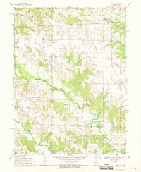
 1965 Eldon1966 Print · USGSSoutheast Iowa in the mid-sixties reveals a landscape shaped by the Des Moines River and a complex network of rail lines. Researchers can locate family sites at Gontermand Cem, trace the Old Railroad Grade, or explore the riverfront at Eldon.
 - 1965 Map of Selma, 1966 Print
 1965 Selma1966 Print · USGSSoutheast Iowa's rural townships are documented here during the mid-sixties, centered on the Selma riverfront and the surrounding family farms. Researchers can trace ancestral roots through dozens of local landmarks like Bethlehem Ch, Valley Sch, and Troy Cem.
 - 1965 Map of Libertyville, 1966 Print
 1965 Libertyville1966 Print · USGSLibertyville and the surrounding townships in the mid-sixties show a landscape shaped by the rail lines and winding creek branches. Researchers can locate family landmarks like Fell Cem, Mt Zion Ch, and the sprawling drainage of Lick Creek.
 - 1965 Map of Douds, 1966 Print
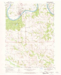
 1965 Douds1966 Print · USGSDouds and Leando face each other across the Des Moines River in the mid-1960s, serving as a hub for both rail transit and local mining. Genealogists can locate several historic burial grounds and congregations, including White Chapel Cem, Zion Ch, and Valentine Cem.
 - 1968 Map of Anson, 1970 Print
 1968 Anson1970 Print · USGSThe Fox River valley along the Missouri-Iowa border is documented here in the late sixties. Genealogists and local historians can trace family burial sites and rural institutions like St Thomas Cem, Duncan Sch, and the settlement at Chambersburg.2 unique versions available
 - 1968 Map of Bonaparte, 1970 Print
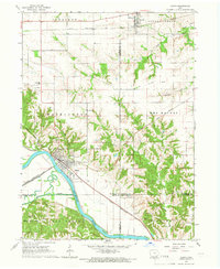
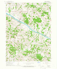
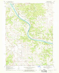
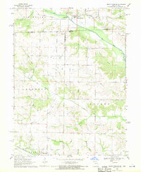
 1968 Bonaparte1970 Print · USGSVan Buren County life centers on the river and rail lines in the late sixties. Genealogists and historians can trace family plots like Thomson Cem and Robb Cem or explore the riverfront layouts of Bonaparte and Bentonsport.2 unique versions available
 - 1968 Map of Croton, 1970 Print
 1968 Croton1970 Print · USGSThe borderlands of Missouri and Iowa are captured here in the late sixties as the Des Moines River winds through timber and farmland. Genealogists and historians can trace the Old Indian Treaty Boundary and locate family burial sites like Shaffer Cem and Walker Cem.2 unique versions available
 - 1968 Map of Keosauqua, 1970 Print
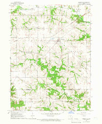
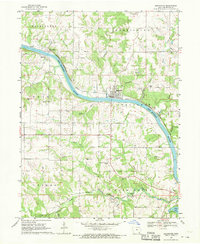
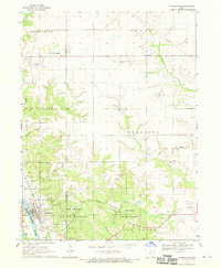
 1968 Keosauqua1970 Print · USGSKeosauqua and the rural townships of Van Buren County are shown in the late sixties as the Des Moines River winds through the heart of the community. Genealogists can trace family heritage across more than ten local burial sites including Oak Lawn Cem, Watkins Cem, and Pratt Cem.
 - 1968 Map of Farmington, 1970 Print
 1968 Farmington1970 Print · USGSFarmington and the surrounding townships in Van Buren and Lee Counties are captured here in the late sixties as the regional rail and forest networks matured. Genealogists and historians can trace the exact locations of Alfrey Cem, Harmony High Sch, and the grounds of Shimek State Forest.2 unique versions available
 - 1968 Map of Mount Sterling, 1970 Print
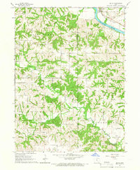
 1968 Mount Sterling1970 Print · USGSCrossing the Iowa-Missouri border in the late sixties, this survey captures the rural landscape between Mount Sterling and Prospect Grove. Genealogists can trace family roots at Harness Cem, Blackledge Cem, and Asbury Ch along the Fox River valley.3 unique versions available
End of results
Showing maps 1-12 of 12
Top cities of Van Buren County
- Keosauqua historical maps
- Farmington historical maps
- Milton historical maps
- Birmingham historical maps
- Bonaparte historical maps
- Stockport historical maps
See more
Frequently asked questions
- What are the different types of historical maps available for Van Buren County?
- What is the oldest map of Van Buren County?
- Where can I purchase historical maps of Van Buren County for my home or office?
- Where can I download high-res historical maps of Van Buren County?
- Are there historical topographic maps available for Van Buren County?
- Is there historical aerial imagery available for Van Buren County?
- Where are historical maps of Van Buren County sourced from?