
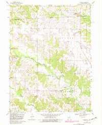
1968 Map of Anson
USGS Topo · Published 1970About this map
The Fox River meanders across this rural landscape along the Iowa Missouri state line during the late 1960s, defining the agricultural character of Clark County. Small communities and rural crossroads such as Anson, Chambersburg, and Rollins anchor the region, connected by a network of light-duty roads and the Chicago Burlington and Quincy railroad line crossing the northwestern corner. The map reveals a deeply rooted local history through its numerous small rural institutions, including the Duncan Sch, Bethlehem Ch, and Union Chapel.
Find a feature on this map
30 named features on this map. Tap any name to fly to it.
Don’t see what you’re looking for? This feature index may not catch every label — zoom into the map to look around manually.
Map Details
Editions of this 1968 Anson Map
2 editions found
Other maps of this area

1903 · Kahoka
USGS Topo · 1:125,000

1949 · Kahoka
USGS Topo · 1:24,000

1950 · Kahoka
USGS Topo · 1:24,000

1950 · Medill
USGS Topo · 1:24,000

1951 · Medill
USGS Topo · 1:24,000

1951 · Wyaconda
USGS Topo · 1:24,000

1958 · Burlington
USGS Topo · 1:250,000

1961 · Burlington
USGS Topo · 1:250,000

1963 · Burlington
USGS Topo · 1:250,000

1968 · Bonaparte
USGS Topo · 1:24,000