
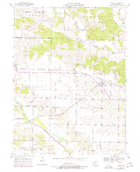
1950 Map of Medill
USGS Topo · Published 1967About this map
Medill serves as a central hub in Clark County where two major railroads intersect, highlighting a period when the rail network dictated the growth of rural Missouri settlements. The Chicago Burlington and Quincy line cuts horizontally across the landscape, crossing the Atchison Topeka and Santa Fe at a sharp angle near the town center. This junction created a concentrated corridor of development between Ashton and Luray, while the surrounding countryside remained defined by a dense grid of one-room schoolhouses like Thompson Sch and Eureka Sch.
Find a feature on this map
32 named features on this map. Tap any name to fly to it.
Don’t see what you’re looking for? This feature index may not catch every label — zoom into the map to look around manually.
Map Details
Editions of this 1950 Medill Map
2 editions found
Other maps of this area

1903 · Kahoka
USGS Topo · 1:125,000

1949 · Kahoka
USGS Topo · 1:24,000

1949 · St. Patrick
USGS Topo · 1:24,000

1950 · Kahoka
USGS Topo · 1:24,000

1950 · Saint Patrick
USGS Topo · 1:24,000

1950 · Neeper
USGS Topo · 1:24,000

1950 · Colony
USGS Topo · 1:24,000

1951 · Colony
USGS Topo · 1:24,000

1951 · Neeper
USGS Topo · 1:24,000

1951 · Medill
USGS Topo · 1:24,000