1900s (20th Century) Maps of Humeston, Iowa
Explore 8 historic maps of Humeston from the 1900s (20th Century). These maps offer a rare glimpse into what life looked like during the 1900s — showing old roads, neighborhoods, homes, and landmarks that have changed or disappeared over time.
Whether you're researching your family's past, planning a metal detecting trip, or studying how Humeston's landscape evolved across the 1900s, these high-resolution maps are a powerful tool for exploring the history of this region.
- Focus on a specific era: All maps on this page are from the 1900s, giving you a focused view of this time period.
- See what’s changed: Compare century-old streets, trails, and buildings to today's modern landscape using overlays and satellite layers.
- Research with precision: Use these maps for genealogy, historical research, land use analysis, or educational projects.
- View, download, or print: Maps are fully viewable online in high resolution, and can be downloaded or printed for your own records.
Start exploring Humeston's history through authentic maps from the 1900s. This is your window into the past.
Humeston, IA maps
(8)- 1934 Map of Humeston
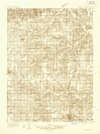 1934 Humeston1934 Print · USGSSouthern Iowa farmland and small-town commerce define this 1930s landscape, where rail lines and river branches meet. Genealogists can trace family roots at Humeston and Corydon or locate rural landmarks like Eden Ch and the Wayne County Farm.3 unique versions available
 - 1937 Map of Corydon
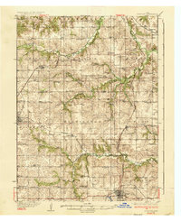 1937 Corydon1937 Print · USGSWayne County and the city of Corydon are captured in the mid-1930s, showing a landscape tightly organized around rail transport and rural education. Genealogists and historians can trace dozens of country schools and churches like Rabbit Ridge Sch, Brown Jug Sch, and Eden Ch.2 unique versions available
 - 1954 Map of Centerville, 1967 Print
 1954 Centerville1967 Print · USGSThe Iowa-Missouri borderlands at mid-century reveal a landscape shaped by river valleys and the height of the regional rail network. Genealogists and historians can trace the paths of the Wabash railroad and locate old townsites like Mystic, Moulton, and Greentop.3 unique versions available
 - 1957 Map of Centerville
 1957 Centerville1957 Print · USGSThe Iowa-Missouri borderlands in the mid-fifties reveal a landscape of river-valley agriculture and vital rail corridors. Genealogists and historians can trace family-named landmarks and small-town growth in Centerville, Kirksville, and along the Wabash railroad line.
 - 1958 Map of Centerville
 1958 Centerville1958 Print · USGSThe Iowa-Missouri borderlands come into focus during the mid-fifties, showing a landscape defined by river valleys and intersecting rail lines. Genealogists and local historians can trace family roots through dozens of rural hubs like Bloomfield, Unionville, and Corydon.
 - 1965 Map of Garden Grove, 1967 Print
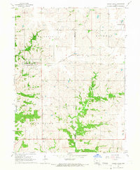 1965 Garden Grove1967 Print · USGSDecatur and Wayne Counties are captured in the mid-1960s, showing the agricultural rhythm of southern Iowa before modernization reshaped its rural landscape. Researchers can trace family roots at Green Bay Cem. or locate regional landmarks like the Chicago Burlington and Quincy railroad and the local Drive-in Theater.
 - 1981 Map of Leon, 1982 Print
 1981 Leon1982 Print · USGSSouthern Iowa and northern Missouri are captured here in the early eighties as the rural landscape balances traditional agriculture with large-scale water management. Researchers can trace the path of the Burlington Northern through Leon or locate early settlements like Decatur City and New Buda.
 - 1982 Map of Humeston, 1983 Print
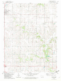 1982 Humeston1983 Print · USGSWayne County farming communities thrive in the early 1980s as the railroad era transitions to the recreational trail of The Cinder Path. Genealogists can locate several rural burial sites like Greenlee Cem and landmarks such as New Zion Ch.
End of results
Showing maps 1-8 of 8
Top cities near Humeston
- Chariton historical maps
- Corydon historical maps
- Allerton historical maps
- Garden Grove historical maps
- Lucas historical maps
- Woodburn historical maps
See more
Frequently asked questions
- What are the different types of historical maps available for Humeston?
- What is the oldest map of Humeston?
- Where can I purchase historical maps of Humeston for my home or office?
- Where can I download high-res historical maps of Humeston?
- Are there historical topographic maps available for Humeston?
- Is there historical aerial imagery available for Humeston?
- Where are historical maps of Humeston sourced from?