1960s Maps of Lost Grove Township, Iowa
Explore 3 historic maps of Lost Grove Township from the 1960s. These maps offer a rare glimpse into what life looked like during the 1960s — showing old roads, neighborhoods, homes, and landmarks that have changed or disappeared over time.
Whether you're researching your family's past, planning a metal detecting trip, or studying how Lost Grove Township's landscape evolved across the 1960s, these high-resolution maps are a powerful tool for exploring the history of this region.
- Focus on a specific era: All maps on this page are from the 1960s, giving you a focused view of this time period.
- See what’s changed: Compare century-old streets, trails, and buildings to today's modern landscape using overlays and satellite layers.
- Research with precision: Use these maps for genealogy, historical research, land use analysis, or educational projects.
- View, download, or print: Maps are fully viewable online in high resolution, and can be downloaded or printed for your own records.
Start exploring Lost Grove Township's history through authentic maps from the 1960s. This is your window into the past.
Lost Grove Township, IA maps
(3)- 1962 Map of Jefferson, 1964 Print
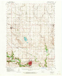 1962 Jefferson1964 Print · USGSGreene County agriculture and rail commerce are at their peak in the early sixties as steam gives way entirely to diesel. Genealogists can locate family plots at Golgotha Cem, trace the rural North Sch, or explore the wetland edges of Goose Lake State Preserve.
 - 1965 Map of Gowrie, 1966 Print
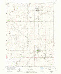 1965 Gowrie1966 Print · USGSGowrie and Callender are captured in the mid-1960s at the height of their importance as a tri-railroad junction. Genealogists and rail historians can trace the paths of the Chicago Rock Island and Pacific and locate local landmarks like Danish Cem and Peterson Airport.
 - 1965 Map of Harcourt, 1966 Print
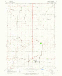 1965 Harcourt1966 Print · USGSWebster County agriculture and rail transport meet in the mid-1960s as these prairie townships expand their drainage and transit networks. Trace the intersections of the Chicago and North Western through Harcourt or locate the Lost Grove Cem and small sidings like Lundgren.2 unique versions available
End of results
Showing maps 1-3 of 3
Top cities near Lost Grove Township
- Fort Dodge historical maps
- Jefferson historical maps
- Ogden historical maps
- Gowrie historical maps
- Dayton historical maps
- Grand Junction historical maps
See more
Top neighborhoods of Lost Grove Township
Frequently asked questions
- What are the different types of historical maps available for Lost Grove Township?
- What is the oldest map of Lost Grove Township?
- Where can I purchase historical maps of Lost Grove Township for my home or office?
- Where can I download high-res historical maps of Lost Grove Township?
- Are there historical topographic maps available for Lost Grove Township?
- Is there historical aerial imagery available for Lost Grove Township?
- Where are historical maps of Lost Grove Township sourced from?