1962 Map of Jefferson
USGS Topo · Published 1964About this map
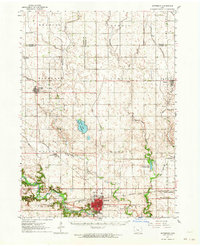
Jefferson serves as the focal point of this Greene County landscape, situated at the confluence of the Raccoon River and Hardin Creek. The mid-century mapping highlights a region deeply integrated with rail transportation, where the Chicago and North Western and Chicago Milwaukee St Paul and Pacific lines intersect. Outside the primary settlements of Grand Junction and Churdan, the terrain is defined by its conservation areas, including the marshlands of Goose Lake State Preserve and the recreation grounds at Spring Lake State Park. For genealogists, the map is a dense resource of rural infrastructure, noting small landmarks like North Sch, the Church of Christ, and numerous burial grounds such as Golgotha Cem and Highland Cem that served the outlying townships.
Find a feature on this map
54 named features on this map. Tap any name to fly to it.
Don’t see what you’re looking for? This feature index may not catch every label — zoom into the map to look around manually.
Map Details
Editions of this 1962 Jefferson Map
This is the sole edition of this map. No revisions or reprints were ever made.
Historical Maps of Jefferson Through Time
1 maps found
Featured Locations
- Gowrie Township, IA
- Jefferson, Grant Township
- Grand Junction, Junction Township
- Churdan, Highland Township
- Paton, Paton Township