1950s Maps of Atchison County, Kansas
Explore 11 historic maps of Atchison County from the 1950s. These maps offer a rare glimpse into what life looked like during the 1950s — showing old roads, neighborhoods, homes, and landmarks that have changed or disappeared over time.
Whether you're researching your family's past, planning a metal detecting trip, or studying how Atchison County's landscape evolved across the 1950s, these high-resolution maps are a powerful tool for exploring the history of this region.
- Focus on a specific era: All maps on this page are from the 1950s, giving you a focused view of this time period.
- See what’s changed: Compare century-old streets, trails, and buildings to today's modern landscape using overlays and satellite layers.
- Research with precision: Use these maps for genealogy, historical research, land use analysis, or educational projects.
- View, download, or print: Maps are fully viewable online in high resolution, and can be downloaded or printed for your own records.
Start exploring Atchison County's history through authentic maps from the 1950s. This is your window into the past.
Atchison County, KS maps
(11)- 1950 Map of Kansas City
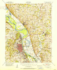
 1950 Kansas City1950 Print · USGSMid-century Kansas and Missouri are captured here during a period of industrial growth and shifting transportation. Genealogists and historians can trace rail lines like the Wabash RR or locate ancestral homes near the Potawatomi Indian Reservation and Horton.
 - 1951 Map of Oak Mills
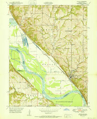
 1951 Oak Mills1951 Print · USGSThe Missouri River borderlands come alive in the early fifties, showing the rural communities of Atchison and Leavenworth counties. Trace local family history through landmarks like Round Prairie Church, Dalbey, and the historic Millwood settlement.2 unique versions available
 - 1951 Map of Leavenworth
 1951 Leavenworth1951 Print · USGSLeavenworth and the Missouri River borderlands are shown here in the early Cold War era, marked by significant federal and military installations. Trace the footprints of Fort Leavenworth, Sherman Air Force Base, and rural landmarks like the Fancy Bottoms School.2 unique versions available
 - 1951 Map of Weston
 1951 Weston1951 Print · USGSThe Missouri-Kansas borderlands come to life in this mid-century survey, showing the river winding past Weston and the northern edge of the Fort Leavenworth Military Reservation. Genealogists can locate family landmarks like Laurel Hill Cemetery and rural schools including Fancy Bottoms School and Burrus School.2 unique versions available
 - 1951 Map of Rushville
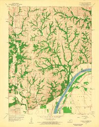
 1951 Rushville1951 Print · USGSThe Missouri River floodplain near Atchison and Rushville is shown here in the early fifties, highlighting a landscape shaped by massive river bends and rail lines. Genealogists can trace family names at Armstrong Cem and locate rural landmarks like Pleasant Valley School or the State Orphan Home.2 unique versions available
 - 1954 Map of Kansas City
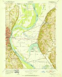
 1954 Kansas City1954 Print · USGSThe Missouri-Kansas borderlands flourished in the post-war era as river commerce and rail networks converged at the Missouri River. Genealogists and historians can trace the foundations of Kansas City and smaller rural hubs like Hiawatha or Sabetha.
 - 1956 Map of Kansas City, 1967 Print
 1956 Kansas City1967 Print · USGSThe Kansas-Missouri border region thrived during the mid-fifties, centered on the growing metropolitan cores and the busy river valleys. Researchers can trace the layout of significant government sites like Fort Leavenworth and the Lake City Army Ammunition Plant.4 unique versions available
 - 1959 Map of Bendena, 1960 Print
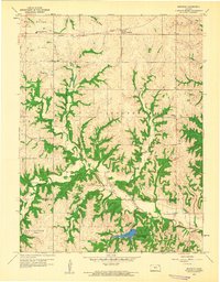 1959 Bendena1960 Print · USGSDoniphan and Atchison counties in the late fifties remained a rural landscape defined by township lines and the east-west rail corridor. Researchers can trace family roots through numerous local sites including Bitner Cem, St Benedict Ch, and Independence Valley Sch.2 unique versions available
 - 1959 Map of Atchison West, 1960 Print
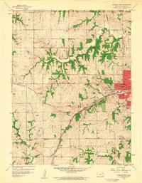 1959 Atchison West1960 Print · USGSAtchison transitioned into a modern hub during the late fifties as rail lines and aviation began to meet expanding suburbs. Genealogists can trace rural roots through numerous country schools like Good Intent Sch and old burial sites including Alderson Cem and Mt Vernon Cemetery.2 unique versions available
 - 1959 Map of Atchison NE, 1960 Print
 1959 Atchison NE1960 Print · USGSDoniphan County in the late fifties shows a rural landscape of ridges and river bottoms along the Missouri River. Researchers can trace the heritage of local communities through landmarks like Doniphan, St Johns Ch, and schools such as Randolph Sch.2 unique versions available
 - 1959 Map of Half Mound, 1961 Print
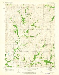 1959 Half Mound1961 Print · USGSThe rural borderlands of Atchison and Jefferson counties are captured here in the late fifties, showing a landscape of upland farms and river valleys. Researchers can trace the legacy of local families at Earnst Cem or locate former schoolhouses like Prairie View Sch and Nichols Sch.3 unique versions available
End of results
Showing maps 1-11 of 11
Top cities of Atchison County
- Atchison historical maps
- Effingham historical maps
- Lancaster historical maps
- Muscotah historical maps
- Huron historical maps
Frequently asked questions
- What are the different types of historical maps available for Atchison County?
- What is the oldest map of Atchison County?
- Where can I purchase historical maps of Atchison County for my home or office?
- Where can I download high-res historical maps of Atchison County?
- Are there historical topographic maps available for Atchison County?
- Is there historical aerial imagery available for Atchison County?
- Where are historical maps of Atchison County sourced from?