1980s Maps of Mount Pleasant Township, Kansas
Explore 3 historic maps of Mount Pleasant Township from the 1980s. These maps offer a rare glimpse into what life looked like during the 1980s — showing old roads, neighborhoods, homes, and landmarks that have changed or disappeared over time.
Whether you're researching your family's past, planning a metal detecting trip, or studying how Mount Pleasant Township's landscape evolved across the 1980s, these high-resolution maps are a powerful tool for exploring the history of this region.
- Focus on a specific era: All maps on this page are from the 1980s, giving you a focused view of this time period.
- See what’s changed: Compare century-old streets, trails, and buildings to today's modern landscape using overlays and satellite layers.
- Research with precision: Use these maps for genealogy, historical research, land use analysis, or educational projects.
- View, download, or print: Maps are fully viewable online in high resolution, and can be downloaded or printed for your own records.
Start exploring Mount Pleasant Township's history through authentic maps from the 1980s. This is your window into the past.
Mount Pleasant Township, KS maps
(3)- 1984 Map of Oak Mills
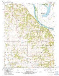 1984 Oak Mills1984 Print · USGSThe Missouri River bluffs on the Kansas-Missouri border come into sharp focus in the early eighties. Researchers can trace the Old Indian Treaty Boundary and locate numerous family-history sites like St Pats Cem and Round Prairie Ch.
 - 1984 Map of Atchison East
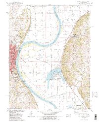 1984 Atchison East1984 Print · USGSThe Missouri River borderlands near Atchison show a mid-1980s landscape of river-bend settlements and agricultural bluffs. Genealogists can locate family names at Sumner Cem and Taylor Cem or trace the early campuses of Benedictine College.2 unique versions available
 - 1985 Map of Atchison
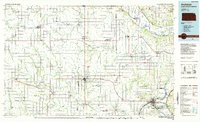 1985 Atchison1985 Print · USGSNortheast Kansas at the mid-eighties shows a landscape of river-bend towns and expansive tribal lands during a period of steady agricultural and rail activity. Local researchers can locate family sites at Mt Hope Cemetery, trace the grounds of Highland College, or explore the limits of the Kickapoo Indian Reservation.
End of results
Showing maps 1-3 of 3
Top cities near Mount Pleasant Township
- Leavenworth historical maps
- Lansing historical maps
- Atchison historical maps
- Kickapoo historical maps
- Shannon historical maps
- Nortonville historical maps
See more
Top neighborhoods of Mount Pleasant Township
Frequently asked questions
- What are the different types of historical maps available for Mount Pleasant Township?
- What is the oldest map of Mount Pleasant Township?
- Where can I purchase historical maps of Mount Pleasant Township for my home or office?
- Where can I download high-res historical maps of Mount Pleasant Township?
- Are there historical topographic maps available for Mount Pleasant Township?
- Is there historical aerial imagery available for Mount Pleasant Township?
- Where are historical maps of Mount Pleasant Township sourced from?