1960s Maps of Chase County, Kansas
Explore 5 historic maps of Chase County from the 1960s. These maps offer a rare glimpse into what life looked like during the 1960s — showing old roads, neighborhoods, homes, and landmarks that have changed or disappeared over time.
Whether you're researching your family's past, planning a metal detecting trip, or studying how Chase County's landscape evolved across the 1960s, these high-resolution maps are a powerful tool for exploring the history of this region.
- Focus on a specific era: All maps on this page are from the 1960s, giving you a focused view of this time period.
- See what’s changed: Compare century-old streets, trails, and buildings to today's modern landscape using overlays and satellite layers.
- Research with precision: Use these maps for genealogy, historical research, land use analysis, or educational projects.
- View, download, or print: Maps are fully viewable online in high resolution, and can be downloaded or printed for your own records.
Start exploring Chase County's history through authentic maps from the 1960s. This is your window into the past.
Chase County, KS maps
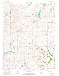
(5)- 1962 Map of Florence SE, 1963 Print
 1962 Florence SE1963 Print · USGSThe Butler and Chase County borderlands come into focus in the early sixties as a landscape of prairie drainage and agricultural sectioning. Genealogists and historians can trace the Railroad Grade and locate features like an isolated Oil Well and the Walnut River.
 - 1967 Map of Thrall, 1968 Print
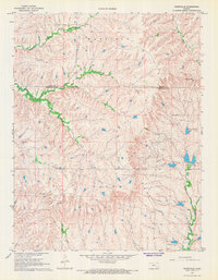
 1967 Thrall1968 Print · USGSIn the late 1960s, the Greenwood County landscape was a patchwork of agricultural townships and active petroleum production. Researchers can trace the legacy of the local oil industry through the Thrall Aagard Oil Field and find family sites like Andrew Cem or the Prairie Chapel Cem.
 - 1967 Map of Teterville, 1968 Print
 1967 Teterville1968 Print · USGSThe Flint Hills of Greenwood County come into focus during the late 1960s, showing a region where oil production meets traditional ranching. Researchers can trace the industrial footprint of Oil Wells near Teterville or locate family sites like High Prairie Cem.
 - 1967 Map of Cassoday, 1968 Print
 1967 Cassoday1968 Print · USGSThe tallgrass prairie of Butler County underwent significant changes in the late sixties as modern highways intersected old rail lines. Researchers can trace the path of the Atchison Topeka and Santa Fe through Cassoday, locate the Cassoday Cem, and follow the winding Walnut River.3 unique versions available
 - 1967 Map of Matfield Green SE, 1968 Print
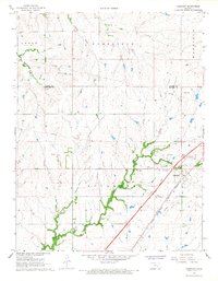
 1967 Matfield Green SE1968 Print · USGSButler and Chase County history is revealed in the 1960s as major transit lines like the Kansas Turnpike cut through the Flint Hills. Genealogists and historians can trace the Old Indian Treaty Boundary and find local landmarks like Thurman and Fox Lake.
End of results
Showing maps 1-5 of 5
Top cities of Chase County
- Cottonwood Falls historical maps
- Strong City historical maps
- Toledo historical maps
- Bazaar historical maps
- Matfield Green historical maps
- Cedar Point historical maps
See more
Frequently asked questions
- What are the different types of historical maps available for Chase County?
- What is the oldest map of Chase County?
- Where can I purchase historical maps of Chase County for my home or office?
- Where can I download high-res historical maps of Chase County?
- Are there historical topographic maps available for Chase County?
- Is there historical aerial imagery available for Chase County?
- Where are historical maps of Chase County sourced from?