1960s Maps of Cedar Vale, Kansas
Explore 2 historic maps of Cedar Vale from the 1960s. These maps offer a rare glimpse into what life looked like during the 1960s — showing old roads, neighborhoods, homes, and landmarks that have changed or disappeared over time.
Whether you're researching your family's past, planning a metal detecting trip, or studying how Cedar Vale's landscape evolved across the 1960s, these high-resolution maps are a powerful tool for exploring the history of this region.
- Focus on a specific era: All maps on this page are from the 1960s, giving you a focused view of this time period.
- See what’s changed: Compare century-old streets, trails, and buildings to today's modern landscape using overlays and satellite layers.
- Research with precision: Use these maps for genealogy, historical research, land use analysis, or educational projects.
- View, download, or print: Maps are fully viewable online in high resolution, and can be downloaded or printed for your own records.
Start exploring Cedar Vale's history through authentic maps from the 1960s. This is your window into the past.
Cedar Vale, KS maps
(2)- 1962 Map of Cedar Vale West, 1963 Print
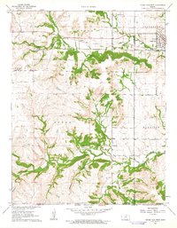 1962 Cedar Vale West1963 Print · USGSCowley County in the early 1960s reveals a landscape shaped by rail, ranching, and the legacy of the Old Indian Treaty Boundary. Genealogists and historians can trace family roots through the Cedar Creek Cem or locate the industrial footprint of local Oil Wells and the Missouri Pacific line.2 unique versions available
 - 1962 Map of Cedar Vale East, 1963 Print
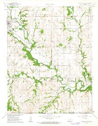 1962 Cedar Vale East1963 Print · USGSChautauqua County’s borderlands come into focus in the early sixties as the Caney River valley transitions into the Oklahoma panhandle. Genealogists and historians can trace the Old Indian Treaty Boundary and locate Osro Falls Cem or the rail-stop at Hewins.3 unique versions available
End of results
Showing maps 1-2 of 2
Top cities near Cedar Vale
Frequently asked questions
- What are the different types of historical maps available for Cedar Vale?
- What is the oldest map of Cedar Vale?
- Where can I purchase historical maps of Cedar Vale for my home or office?
- Where can I download high-res historical maps of Cedar Vale?
- Are there historical topographic maps available for Cedar Vale?
- Is there historical aerial imagery available for Cedar Vale?
- Where are historical maps of Cedar Vale sourced from?